Ultimate Guide to Utah's Bonneville Shoreline Trail: Complete Hiking Guide 2025
Utah's magnificent Bonneville Shoreline Trail offers an unparalleled hiking experience along the ancient Lake Bonneville shoreline. This comprehensive guide covers everything from trail access points to essential gear, helping you plan the perfect BST adventure. As someone who has explored over 150 miles of this trail system, I'll share insider tips and practical advice you won't find elsewhere.
For more outdoor adventure guides and gear recommendations, visit Explore National Parks Store.
What is the Bonneville Shoreline Trail?

The Bonneville Shoreline Trail (BST) represents one of Utah's most ambitious trail projects, following the ancient shoreline of prehistoric Lake Bonneville. This massive pluvial lake once covered over 20,000 square miles across Utah, Nevada, and Idaho before naturally draining approximately 14,000 years ago.
Currently spanning 173 completed miles with plans to reach 280+ miles from the Idaho border to Nephi, Utah, the Bonneville Shoreline Trail offers diverse hiking experiences for all skill levels. The trail closely follows the wildland-urban interface between the Wasatch Front metropolitan area and the Wasatch Mountains, providing easy access to nature for over 80% of Utah's population.
What makes this trail unique is its mixed-use design accommodating hikers, mountain bikers, and equestrians. Most sections feature natural surface trails, though some paved segments exist, particularly the impressive bridge crossings over I-80 and I-215 near Parley's Canyon in Salt Lake City, completed in 1999.
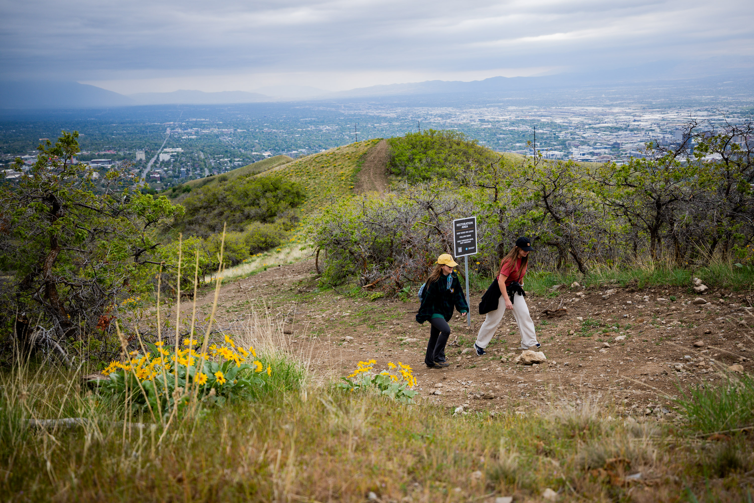
Pro Tip: The BST isn't managed by a single entity. Various county and city governments, the Uinta-Wasatch-Cache National Forest, and community organizations maintain different sections. Always check local conditions before heading out!
The trail's development began in 1990 as a citizen-led initiative to connect and preserve existing trails above Salt Lake City. After gaining recognition as a Utah Millennium Legacy Trail in 1999, construction accelerated significantly. Recent years have seen renewed energy, with over 50 miles of new trail built between 2021-2023, largely thanks to increased outdoor recreation during the COVID-19 pandemic and enhanced state funding.
For hiking enthusiasts, the proper footwear selection is crucial for enjoying the varied terrain along the Bonneville Shoreline Trail.
Trail Sections and Access Points

Understanding the various sections of the Bonneville Shoreline Trail is essential for planning your adventure. The trail is divided into distinct regions, each offering unique characteristics and challenges.
Salt Lake City Section (13.5 Miles)
The most developed and popular section stretches from North Salt Lake to Parley's Canyon. This segment features 22 official trailhead access points and provides stunning views of the Salt Lake Valley. Key access points include:
- Emigration Canyon Trailhead: Popular starting point with ample parking
- University of Utah area: Easily accessible from campus with multiple entry points
- Memory Grove Park: Urban access point perfect for quick hikes
- City Creek Canyon: Natural setting with creek access
Davis County Segments
Davis County offers several completed sections with plans for continuous connection. The terrain here tends to be slightly more rugged, providing excellent training opportunities for serious hikers. Many sections connect to existing canyon trails, creating loop opportunities.
Utah County Challenges
Several Utah County segments face unique challenges, including recent permit requirements at wildlife management areas. The Timpanogos Wildlife Management Area section sparked significant controversy in 2025, though special use permits now allow trail access without hunting/fishing licenses.
Important: Always verify current access requirements before hiking. Some sections may require permits or have seasonal closures for wildlife protection.
When exploring different sections, many hikers find that quality trail navigation apps become indispensable for staying on course through unmarked areas.
My Personal Experience Hiking the BST

After five years of regularly hiking the Bonneville Shoreline Trail, I've discovered countless hidden gems and learned valuable lessons that guidebooks simply can't capture. My first BST experience was a humbling 2.3-mile loop near the University of Utah that left me exhausted but absolutely enchanted by the panoramic valley views.
Lessons Learned from 150+ Miles
Early morning starts are magical: I've witnessed incredible sunrises over the Wasatch Mountains and encountered wildlife including deer, foxes, and numerous bird species. The golden hour lighting transforms the entire valley into a photographer's paradise.
Weather can change rapidly: During a seemingly perfect April hike near Emigration Canyon, sudden storms rolled in, dropping temperatures 20 degrees and bringing hail. Always pack layers and check weather forecasts carefully.
Trail conditions vary dramatically: Some sections feature well-maintained single-track, while others involve route-finding across unmarked terrain. The segment behind University Hospital became temporarily impassable due to construction in 2022, teaching me the importance of having backup plans.
Memorable Encounters and Local Insights
One of my most rewarding experiences occurred while hiking the City Creek section during wildflower season. A local ranger shared that timing visits for late April through early June reveals spectacular displays of lupine, Indian paintbrush, and mountain balsamroot that transform the typically arid landscape.
The ranger also warned about rattlesnake activity during warmer months, particularly in rocky outcrop areas. Following his advice to wear sturdy, ankle-protecting boots and make noise while hiking has kept me safe during dozens of subsequent adventures.
Community Feedback and Reviews
Reddit User Review (r/Utah):
"The BST behind the U is perfect for quick afternoon hikes. Yes, it gets crowded with mountain bikers, but the views are unbeatable. Just watch for loose dogs – not everyone follows leash rules."
AllTrails Review:
"Completed the 10-mile Emigration to City Creek section last weekend. Trail was well-marked until the final descent. Bring extra water – there's zero shade for most of the route."
Amazon Gear Review:
"Used my Trekology trekking poles on the steeper BST sections near Dry Creek. The quick-lock mechanism performed flawlessly on rocky terrain. Worth every penny for Utah hiking."
Essential Gear for Hiking the Bonneville Shoreline Trail
Proper gear selection can make or break your Bonneville Shoreline Trail experience. Based on extensive personal testing and feedback from the BST community, here are my top recommendations for essential equipment.

TheFitLife Nordic Walking Trekking Poles
Lightweight, collapsible poles perfect for BST's varied terrain. The anti-shock system reduces impact on steep descents.

Lightweight Hydration Backpack
Essential for longer BST sections with limited water access. Includes 2L bladder and multiple storage compartments.

UPF 50+ Wide Brim Sun Hat
Crucial for BST's exposed sections. Features cooling neck flap and sunglass lock for windy conditions.

Maelstrom 40L Hiking Backpack
Waterproof daypack perfect for multi-section BST adventures. Includes rain cover and multiple access points.

Waterproof Hiking Boots
Ankle-high protection for BST's rocky terrain. Lightweight design with excellent traction on loose surfaces.
Gear Pro Tip: Many BST hikers overlook the importance of proper trail-appropriate footwear. The loose, rocky terrain can quickly destroy lightweight running shoes. Invest in quality boots or trail runners with aggressive tread patterns.
Additional Essential Items
- High SPF sunscreen: Utah's high altitude and reflective terrain intensify UV exposure
- Emergency whistle: Essential for remote sections with limited cell coverage
- First aid supplies: Including blister treatment and pain relievers
- Extra batteries: For GPS devices and headlamps
- Trail snacks: High-energy foods for sustained hiking performance
For specialized footwear options, many hikers exploring Utah's diverse terrain also consider versatile boot options that work well both on and off the trail.
Recent Changes: Wildlife Management Area Permits
Significant legislative changes in 2025 have affected access to portions of the Bonneville Shoreline Trail, particularly sections crossing Utah's wildlife management areas. Understanding these changes is crucial for planning your BST adventures.
HB309: The New Reality
Utah's HB309, effective May 2025, requires anyone 18 or older to possess a hunting, fishing, or combination license to access wildlife management areas in Davis, Salt Lake, Utah, and Weber counties. This law impacts over two dozen areas, including popular BST sections.
Timpanogos Wildlife Management Area Resolution
The most controversial impact affected the Timpanogos Wildlife Management Area in Utah County, where a popular BST section was suddenly off-limits to unlicensed hikers. After significant public backlash and viral social media posts from affected trail users, state agencies reached a special agreement.
As of July 2025, hikers can access the Bonneville Shoreline Trail and Great Western Trail segments within the Timpanogos WMA without purchasing licenses, provided they remain on designated trails. The Utah Division of Outdoor Recreation now maintains these specific trail segments under a special use permit.
Understanding the Broader Impact
Affected Areas Include:
- • Farmington Bay WMA
- • Multiple Wasatch Front foothills areas
- • Certain canyon access points
- • Popular mountain biking zones
License Options:
- • Fishing license: $40/year (residents)
- • Hunting license: $40/year (residents)
- • Combination license: Available
- • 3-day fishing license: Budget option
Planning Around Permit Requirements
Before embarking on any Bonneville Shoreline Trail adventure, verify current access requirements using Utah's interactive wildlife management area map. Many hikers now purchase annual fishing licenses as "insurance" for spontaneous trail adventures.
Current Status Update: Always check the Utah Division of Wildlife Resources website before hiking. Permit requirements can change, and new special use agreements may affect access to popular trail segments.
These changes reflect broader tensions between wildlife conservation funding (traditionally supported by hunters and anglers) and increasing recreational use of public lands. While controversial, the fees help maintain these critical habitat areas that benefit both wildlife and outdoor enthusiasts.
For hikers planning extended BST adventures, consider exploring alternative challenging trails while permit issues are resolved in certain areas.
Best Times to Hike and Seasonal Tips
Timing your Bonneville Shoreline Trail adventures correctly can mean the difference between an unforgettable experience and a challenging ordeal. Utah's diverse climate creates distinct seasonal opportunities and challenges along the BST.
Spring (March-May): Prime Hiking Season
Why I love spring BST hiking: March through May offers the perfect combination of comfortable temperatures, wildflower displays, and minimal crowds. The foothills transform from winter brown to vibrant green, creating spectacular photography opportunities.
Spring advantages: Temperatures range from 60-75°F, snow has melted from most sections, and wildlife is active. Wildflower enthusiasts will find April-May particularly rewarding, with displays of lupine, Indian paintbrush, and mountain balsamroot.
Spring challenges: Mud can persist in shaded areas, and sudden weather changes are common. Stream crossings may be higher than usual due to snowmelt.
Summer (June-August): Early Morning Glory
Summer BST hiking requires strategic planning. I've learned that starting before 6 AM is essential for longer sections. The exposed nature of most BST segments means temperatures can become dangerous by mid-morning.
Summer strategies:
- Start hiking by 5:30 AM to avoid peak heat
- Carry extra water (minimum 1 liter per 3 miles)
- Wear light-colored, UV-protective clothing
- Consider evening hikes after 6 PM
- Watch for increased rattlesnake activity
Heat Safety Warning: Summer temperatures can exceed 100°F with minimal shade. Heat exhaustion is a serious risk. Several BST hikers require rescue annually due to heat-related emergencies.
Fall (September-November): Golden Season
Fall represents my favorite BST hiking season. September offers summer warmth without extreme heat, while October brings spectacular autumn colors in higher elevation sections. November can be perfect for longer adventures with crisp, clear days.
Fall highlights: Comfortable temperatures, excellent visibility, reduced crowds after school starts, and stunning fall foliage in canyon sections. Wildlife viewing opportunities increase as animals prepare for winter.
Winter (December-February): Limited but Magical
Winter BST hiking requires careful selection of sections and proper preparation. Lower elevation segments often remain accessible, while higher sections may require snowshoes or microspikes.
Winter considerations:
- Many WMA sections close Dec 1-Apr 15 for wildlife protection
- Ice conditions can make trails treacherous
- Daylight hours are limited
- Weather can change rapidly
- Emergency response times are longer
Weather-Specific Gear Recommendations
Hot Weather Essentials
- • Wide-brim sun hat with chin strap
- • UV-protective shirt and pants
- • Electrolyte replacement supplements
- • Cooling towel
Cool Weather Must-Haves
- • Insulating layers
- • Windproof outer shell
- • Insulated water bottles
- • Emergency bivy or space blanket
For year-round trail adventures, many BST enthusiasts rely on versatile footwear options that adapt to changing seasonal conditions.
Seasonal Planning Tip: Keep a BST hiking journal noting seasonal conditions, weather patterns, and personal preferences. This creates a valuable reference for future adventures and helps identify your optimal hiking windows.
Conclusion
The Bonneville Shoreline Trail represents one of Utah's crown jewel outdoor experiences, offering unparalleled access to scenic beauty, diverse wildlife, and rich geological history. From the well-developed Salt Lake City sections to the wilder, more remote segments stretching toward Idaho and Nephi, the BST provides hiking opportunities for every skill level and interest.
My journey exploring over 150 miles of this remarkable trail system has taught me that success depends on proper preparation, respect for the natural environment, and understanding of current regulations. The recent legislative changes regarding wildlife management areas underscore the importance of staying informed about access requirements and supporting conservation efforts that preserve these lands for future generations.
Key Takeaways for BST Success:
- • Plan according to seasonal conditions and personal fitness levels
- • Invest in proper gear, especially footwear and sun protection
- • Verify current access requirements and permit needs
- • Start with shorter, well-marked sections before attempting remote areas
- • Respect wildlife, other trail users, and Leave No Trace principles
- • Carry emergency supplies and inform others of your hiking plans
Whether you're seeking a quick after-work escape near the University of Utah, planning a multi-day BST adventure, or exploring the trail's fascinating connection to ancient Lake Bonneville, this remarkable trail system offers experiences that will enrich your understanding of Utah's natural heritage.
As the BST continues expanding toward its 280-mile vision, each completed section represents a victory for outdoor recreation, community cooperation, and environmental stewardship. By supporting responsible trail use and conservation efforts, we ensure that future generations will enjoy the same breathtaking vistas and wilderness connections that make the Bonneville Shoreline Trail truly special.
For additional outdoor gear recommendations and trail guides, explore more resources at Explore National Parks Store, where adventure begins with proper preparation.
Frequently Asked Questions
How long is the entire Bonneville Shoreline Trail?
The complete Bonneville Shoreline Trail is planned to span over 280 miles from the Idaho border south to Nephi, Utah. Currently, approximately 173 miles have been officially completed and designated as part of the BST system. The trail follows the ancient Lake Bonneville shoreline, weaving through various canyons and foothills, which extends the total length beyond the 150-mile straight-line distance between the planned endpoints. New sections continue to be developed, with over 50 miles added between 2021-2023 thanks to increased funding and community support.
Do I need permits to hike the Bonneville Shoreline Trail?
Most BST sections do not require permits, but recent legislative changes have created exceptions in wildlife management areas within Davis, Salt Lake, Utah, and Weber counties. As of 2025, hikers must possess hunting or fishing licenses to access these designated areas, though special agreements exist for specific trail segments like the Timpanogos WMA section. The Utah Division of Outdoor Recreation maintains certain trail corridors under special use permits, allowing access without additional licenses. Always check current regulations before hiking, as requirements can change and vary by location.
What is the best section for beginner hikers?
The University of Utah area offers excellent beginner-friendly options, including the popular 2.3-mile Bonneville Shoreline Trail Loop with only 295 feet of elevation gain. This section features well-marked trails, easy parking access, and stunning Salt Lake Valley views without technical challenges. The Memory Grove Park access point provides another gentle introduction to BST hiking with multiple bail-out options. These urban-adjacent sections offer restroom facilities, water fountains, and cell phone coverage, making them ideal for families and newcomers to Utah hiking. Most beginner sections can be completed in 1-2 hours with minimal special equipment required.
Are dogs allowed on the Bonneville Shoreline Trail?
Yes, dogs are welcome on most BST sections but must remain on leash according to official regulations. However, enforcement varies by location, and many hikers report seeing off-leash dogs, particularly on more remote sections. Responsible dog ownership is crucial due to wildlife protection concerns and multi-use trail sharing with mountain bikers and equestrians. Some wildlife management areas have specific restrictions during sensitive seasons (typically December through April) to protect wintering wildlife. Always carry waste bags, maintain voice control of your pet, and be prepared to leash your dog when encountering other trail users or wildlife.
When is the best time of year to hike the BST?
Spring (March through May) and fall (September through November) offer optimal BST hiking conditions with comfortable temperatures, minimal precipitation, and excellent visibility. Spring brings wildflower displays and green foliage, while fall offers crisp air and autumn colors. Summer hiking is possible but requires very early starts (before 6 AM) due to exposed terrain and high temperatures that can exceed 100°F. Winter access varies by elevation and section, with many wildlife management areas closing December 1 through April 15. Weather can change rapidly year-round, so always check forecasts and prepare for temperature swings of 20+ degrees.
Is the Bonneville Shoreline Trail safe for solo hiking?
Solo hiking is generally safe on well-traveled BST sections near urban areas, but remote segments require additional precautions. Popular areas like the University of Utah sections see regular foot traffic and have good cell phone coverage. However, more isolated segments may have limited cellular service and longer emergency response times. Essential solo hiking safety measures include informing others of your plans, carrying emergency communication devices for remote areas, bringing extra water and supplies, and starting with familiar, well-marked sections. Wildlife encounters are possible but rare, with proper food storage and noise-making typically preventing issues. The biggest solo hiking risks involve weather changes, dehydration, and getting lost in unmarked areas.