Presidential Traverse: The Ultimate Guide to New Hampshire's Most Epic Hiking Adventure
The Presidential Traverse stands as one of America's most challenging and rewarding hiking experiences, crossing eight 4,000+ foot peaks across New Hampshire's White Mountains. This legendary 23-mile journey tests even experienced hikers with brutal elevation changes, unpredictable weather, and relentless rocky terrain. Having completed this epic traverse multiple times, I'll share everything you need to know to conquer this bucket-list adventure safely. For more outdoor adventures and gear recommendations, visit our homepage.
What is the Presidential Traverse

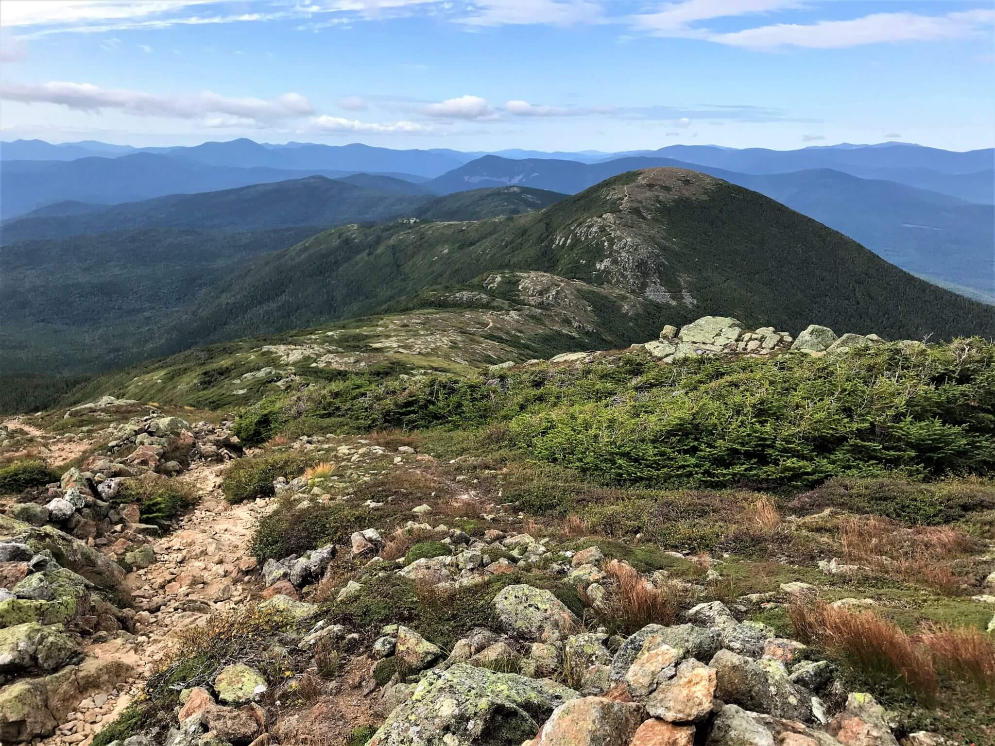
The Presidential Traverse is arguably the most iconic and challenging hike in New Hampshire's White Mountains National Forest. This legendary point-to-point trek spans approximately 23 miles and ascends eight named peaks, seven of which exceed 4,000 feet in elevation. The traverse gets its presidential moniker from the peaks named after U.S. presidents: Madison, Adams, Jefferson, Washington, Monroe, Eisenhower, Pierce, and Jackson.
The Presidential Peaks Overview
Northern Presidentials (Most Challenging):
- Mount Madison: 5,367 feet
- Mount Adams: 5,774 feet
- Mount Jefferson: 5,712 feet
- Mount Washington: 6,288 feet (highest peak in Northeast)
Southern Presidentials (More Manageable):
- Mount Monroe: 5,384 feet
- Mount Eisenhower: 4,780 feet
- Mount Pierce: 4,310 feet
- Mount Jackson: 4,052 feet
What sets the Presidential Traverse apart from other long-distance hikes is its extreme exposure. You'll spend approximately 10-14 miles completely above treeline, traversing alpine tundra with zero protection from the elements. This exposure, combined with the White Mountains' notoriously unpredictable weather, creates conditions that can shift from pleasant to life-threatening within minutes.
The traverse typically takes 1-3 days to complete, with most experienced hikers opting for a 2-day itinerary to fully appreciate the spectacular views and minimize risk. The total elevation gain exceeds 9,000 feet, making it one of the most physically demanding hikes on the East Coast. For those serious about tackling challenging terrain, proper footwear selection becomes absolutely critical for success and safety.
Route Planning and Trail Options
Direction: North to South (Recommended)
The vast majority of hikers, including myself, tackle the Presidential Traverse from north to south for several compelling reasons. Starting from the Appalachia Trailhead near Gorham, NH, you'll face the most technical and demanding terrain while your legs are fresh. The northern peaks—Madison, Adams, Jefferson, and Washington—feature relentless boulder fields and steep granite slabs that become exponentially more dangerous when fatigue sets in.
Key Trailheads and Access Points
Northern Start (Recommended): Appalachia Trailhead - Valley Way or Airline Trail
Southern Finish: Crawford Notch/Highland Center - Crawford Path
Alternative: Some experienced hikers start at Great Gulf for a more challenging approach
Distance and Duration Options
The Presidential Traverse offers flexibility in both route selection and duration, though each choice comes with trade-offs. Understanding these options is crucial for proper planning and safety.
1-Day Push (18-23 miles)
Duration: 12-18 hours
For elite hikers only. Requires starting before dawn and potentially finishing in darkness. High risk if weather deteriorates.
2-Day Split (Most Popular)
Duration: 2 days, 1 night
Ideal balance of challenge and safety. Stay at AMC huts or designated campsites. Most manageable for experienced hikers.
3-Day Leisurely
Duration: 3 days, 2 nights
Allows time to summit all peaks, enjoy scenery, and handle weather delays. Best for first-timers or photography.
Based on Reddit discussions and experienced hiker feedback, the 18-mile figure often cited refers to the core traverse without all summit detours, while 23+ miles includes every presidential peak and the full Jackson extension. When planning with tools like AllTrails, always verify distances and add buffer time for the challenging White Mountains terrain.
Trail Conditions and Navigation
The Presidential Traverse follows a complex network of interconnected trails, primarily utilizing the Appalachian Trail for the central ridge section. Unlike many western trails, White Mountain trails are marked with painted blazes, cairns (rock piles), and wooden signs rather than continuous trail tread.
Above treeline, navigation relies heavily on cairns—carefully constructed rock piles that mark the path across seemingly endless boulder fields. In poor visibility conditions (fog, snow, or storms), these cairns become literal lifelines. I've personally experienced whiteout conditions where cairns spaced 20-30 yards apart were barely visible, making navigation extremely challenging even for experienced hikers.
My Personal Presidential Traverse Experience

Day 1: The Northern Gauntlet (Valley Way to Lakes of the Clouds)
My first Presidential Traverse attempt was humbling in ways I never anticipated. Despite years of hiking experience and what I considered excellent fitness, nothing truly prepared me for the relentless nature of the northern peaks. I started via Valley Way at 5:30 AM, hoping to reach Madison Spring Hut by 8:00 AM. What I thought would be a straightforward 3.8-mile warm-up turned into a three-and-a-half-hour sufferfest.
The Valley Way trail, while considered the "easier" approach to Madison, gains over 3,500 feet in less than 4 miles through increasingly steep terrain. The final mile transitions from protected forest to exposed alpine zone, where the temperature dropped 20 degrees and winds immediately reminded me why proper layering systems are non-negotiable in the Whites.
"The rocks between Madison and Adams are unlike anything I've hiked elsewhere. Every step requires deliberate placement, and the constant up-and-down motion over boulders destroyed my quads by mile 8. What looked like 'just another mile' on the map translated to 90+ minutes of technical scrambling." - Personal journal entry
By the time I reached Mount Washington at 2:00 PM, I was already 2 hours behind schedule despite maintaining what felt like a punishing pace. The summit's tourist facilities—complete with cars, gift shop, and restaurant—felt surreal after hours of wilderness solitude. I spent 45 minutes warming up, refueling with hot soup, and checking updated weather forecasts before continuing south.
Weather Challenges and Lessons Learned
The southern half of my traverse coincided with rapidly deteriorating conditions. What started as partly cloudy skies evolved into thick fog, then intermittent drizzle, and finally steady rain by evening. The transition illustrated why Mount Washington Observatory holds the world record for highest surface wind speed—weather systems accelerate dramatically as they encounter the presidential ridge.
Navigation became increasingly challenging as visibility dropped below 50 yards. The typically obvious cairns marking the Crawford Path seemed to disappear in the mist, forcing me to rely on compass bearings and pace counting between markers. This experience reinforced the critical importance of carrying proper navigation tools and knowing how to use them confidently.
I'll never forget the relief of seeing the Lakes of the Clouds Hut emerge from the fog at 7:30 PM. The hut crew, despite serving dinner hours earlier, graciously heated up leftover turkey stew and provided a warm bunk for the night. Fellow hikers shared stories of similar challenges, creating the camaraderie that makes AMC huts special. For those considering overnight stays, investing in quality insulated footwear for around camp becomes invaluable during cooler mountain evenings.
User Experience Summary: "Worth Every Painful Step"
Reddit User u/WhiteMountainVet: "Completed the Presi in 2 days last September. The northern section humbled me—took 8 hours just to reach Washington. But the sunrise from Monroe made every blister worthwhile."
Amazon Review (Merrell boots): "These boots saved my feet during the Presidential Traverse. The rocky terrain would have destroyed lighter shoes. Waterproofing held up through 6+ hours of rain."
Quora Response: "After failing my first attempt due to weather, I learned the importance of flexible itineraries. The mountains dictate your schedule, not the other way around."
Essential Gear and Equipment
The Presidential Traverse demands equipment capable of handling extreme weather swings, technical terrain, and potential emergency situations. Based on my experience and extensive research, here are the critical gear categories and specific recommendations.
Footwear: Your Foundation for Success
Merrell Moab 3 Mid Waterproof Hiking Boot
The gold standard for White Mountain hiking. Waterproof protection, aggressive tread, and ankle support essential for boulder hopping. Hundreds of traverse completers swear by this boot's durability and comfort.
Backpack: Carry Your World Comfortably
Osprey Renn 50L Women's Backpacking Backpack
Perfect capacity for 2-3 day traverses with superior comfort and organization. Anti-Gravity suspension system distributes weight effectively during long ascents. Includes integrated rain cover for unpredictable White Mountain weather.
Trekking Poles: Essential for Stability
Black Diamond Trail Sport Trekking Poles
Lightweight aluminum construction with FlickLock adjustability. Absolutely crucial for navigating boulder fields safely and reducing knee impact during long descents. Comfortable grip even with wet gloves.
Water Purification: Stay Hydrated Safely
Sawyer Products Mini Water Filtration System
Ultra-lightweight backup filtration for natural water sources. While AMC huts provide treated water, having reliable filtration ensures you're never without safe drinking water on this demanding trek.
Navigation: Never Lose Your Way
AMC White Mountain Trail Map Set
Official waterproof maps covering the entire Presidential Range. Essential backup to electronic navigation. Detailed topography shows elevation profiles, water sources, and emergency exit routes.
Beyond these essential items, the Presidential Traverse demands additional gear for safety and comfort. Weather protection including rain gear, insulating layers, and emergency shelter becomes critical above treeline. Many experienced hikers also recommend bringing spare footwear for hut stays and stream crossings.
Safety and Weather Considerations
Weather: The Ultimate Challenge Factor
Mount Washington holds the world record for highest surface wind speed at 231 mph, recorded in 1934. While you're unlikely to encounter such extremes, understanding the Presidential Range's notorious weather patterns is crucial for safe completion of your traverse.
Critical Weather Facts
- • Temperature drops 3-5°F per 1,000 feet of elevation gain
- • Wind speeds increase dramatically above treeline
- • Weather can change from clear to life-threatening in under 30 minutes
- • Hypothermia risk exists year-round, even in summer
- • Lightning strikes are common on exposed peaks
Before any Presidential Traverse attempt, I religiously check multiple weather sources: Mount Washington Observatory's higher summit forecast, National Weather Service aviation forecasts, and real-time observations from the summit weather station. Even with detailed forecasts, conditions above treeline can vary dramatically from valley predictions.
Seasonal Considerations and Timing
The Presidential Traverse hiking season runs roughly from late May through mid-October, though conditions vary significantly by elevation and year. Each season presents unique challenges and opportunities that dramatically affect your experience.
Early Season (May-June)
- • Snowpack lingers above 4,000 feet
- • Microspikes often necessary
- • Fewer crowds, pristine conditions
- • Stream crossings at peak flow
- • Weather highly unpredictable
Peak Season (July-September)
- • Most stable weather conditions
- • All huts and facilities open
- • Crowded trails and summits
- • Afternoon thunderstorms common
- • Alpine wildflowers in bloom
Emergency Preparedness and Bail-Out Options
The Presidential Traverse's length and exposure mean that weather emergencies are not a matter of if, but when. Having a solid emergency plan and knowing your bail-out options can mean the difference between an epic adventure story and a search-and-rescue operation.
Key escape routes include the Ammonoosuc Ravine Trail from Lakes of the Clouds, the Great Gulf Trail from the northern peaks, and various connecting trails that drop quickly below treeline. Each emergency exit requires careful navigation and adds significant distance to your hike, but they provide crucial safety margins when conditions deteriorate.
"During my second traverse attempt, deteriorating weather forced me to bail via Great Gulf after reaching Jefferson. The 4-mile descent felt endless in driving rain, but it was absolutely the right decision. The mountains will always be there—your safety comes first." - Personal experience
Communication devices deserve special consideration for Presidential Traverse attempts. While cell coverage exists on some peaks, dead zones are common in valleys and during bad weather. Personal locator beacons (PLBs) or satellite communicators provide reliable emergency communication regardless of conditions. Many experienced hikers, including those who frequent challenging routes like the Manitou Incline, carry these devices for peace of mind on technical terrain.
Accommodation and Logistics
AMC Hut System: Mountain Hospitality
The Appalachian Mountain Club operates three full-service huts along the Presidential Traverse: Madison Spring Hut, Lakes of the Clouds Hut, and Mizpah Spring Hut. These stone and timber structures provide heated bunks, home-cooked meals, and crucial weather information in an otherwise harsh alpine environment.
AMC Hut Logistics and Costs
Madison Spring Hut
Location: Base of Mount Madison
Capacity: 50 guests
Cost: $145-185/night
Lakes of the Clouds
Location: Between Washington & Monroe
Capacity: 90 guests
Cost: $155-195/night
Mizpah Spring Hut
Location: Near Mount Pierce
Capacity: 60 guests
Cost: $145-175/night
Prices vary by season and day of week. Reservations open in January and sell out quickly for peak season.
Budget-Friendly Camping Options
For hikers seeking more affordable accommodations, several tent sites and self-service shelters provide alternatives to the AMC huts. These options require carrying additional gear but offer greater flexibility and significant cost savings.
The Randolph Mountain Club operates several self-service cabins and shelters near the northern peaks, including Gray Knob, Crag Camp, and The Perch. These rustic accommodations operate on a first-come, first-served basis with modest overnight fees ($15-25). They provide basic shelter and cooking facilities but require hikers to bring their own sleeping gear and food.
Transportation and Shuttle Services
The point-to-point nature of the Presidential Traverse creates logistical challenges for vehicle placement. The AMC operates a seasonal hiker shuttle service connecting major trailheads, though timing can be restrictive for multi-day itineraries.
Shuttle and Transportation Tips
- • AMC shuttle runs June through mid-October
- • Reservations required, book well in advance
- • Cost: $23-30 per person depending on distance
- • Two-car shuttles provide maximum flexibility
- • Taxi services available but expensive ($100+)
Many experienced hikers arrange their own car shuttles by parking at the finish point (Crawford Notch/Highland Center) and arranging transportation to the start (Appalachia). This approach provides maximum flexibility and eliminates dependence on shuttle schedules, particularly important if weather forces itinerary changes.
Video Guide: Presidential Traverse Overview
Frequently Asked Questions
How difficult is the Presidential Traverse for experienced hikers?
The Presidential Traverse ranks among the most challenging day hikes in the eastern United States, even for experienced hikers. The combination of 23+ miles, 9,000+ feet of elevation gain, technical rock scrambling, and extended above-treeline exposure creates a formidable challenge. Most experienced hikers find the traverse significantly more demanding than other long-distance hikes due to the relentless rocky terrain and weather exposure. Even seasoned backpackers often underestimate the time required, with many taking 50-100% longer than anticipated. The northern peaks (Madison through Washington) are particularly brutal, featuring continuous boulder fields that slow progress to 1-1.5 miles per hour. Success requires excellent fitness, extensive hiking experience, and meticulous preparation.
What's the best time of year to attempt the Presidential Traverse?
Late July through early September offers the most favorable conditions for Presidential Traverse attempts, though each season presents unique challenges. Peak summer (July-August) provides the most stable weather, fully operational AMC huts, and minimal snow coverage above treeline. However, this period also brings afternoon thunderstorms, crowds, and higher accommodation costs. Early fall (September) often features spectacular foliage, cooler temperatures, and fewer crowds, but weather becomes increasingly unpredictable with potential early snow. Spring attempts (May-June) require winter gear for lingering snowpack and offer pristine conditions but highly volatile weather. Late fall and winter traverses are possible but require advanced mountaineering skills and specialized equipment. First-time traversers should target the July-September window for optimal success chances.
Can I complete the Presidential Traverse in one day safely?
Single-day Presidential Traverse completions are possible but require exceptional fitness, perfect weather, and extensive White Mountains experience. The typical one-day traverse covers 18-23 miles with 9,000+ feet of elevation gain in 12-18 hours, often requiring pre-dawn starts and potential night hiking. Success demands maintaining 1.5-2 mph pace over technical terrain while carrying emergency gear for rapidly changing conditions. Weather deterioration during a one-day push creates serious risk, as bailout options are limited and exposure time is maximized. Most experienced White Mountain hikers recommend 2-3 day itineraries for safety and enjoyment. If attempting in one day, have detailed contingency plans, carry overnight survival gear, and be prepared to turn back if conditions deteriorate. Consider your experience level honestly—this isn't the hike to push personal limits.
What emergency supplies should I carry on the Presidential Traverse?
Presidential Traverse emergency preparedness extends beyond typical day hiking gear due to extended above-treeline exposure and remoteness from help. Essential emergency items include: comprehensive first aid kit with blister treatment, emergency shelter (bivy sack or lightweight tarp), extra food for 24+ hours, water purification method, fire starting materials, emergency whistle, and reflective signaling device. Weather protection must include full rain gear, insulating layers, hat, and gloves regardless of forecast. Navigation backup requires paper maps, compass, and ideally GPS device with extra batteries. Consider personal locator beacon (PLB) or satellite communicator for areas without cell coverage. Emergency cash for AMC hut stays if weather forces unexpected overnight. Headlamp with extra batteries is crucial even for planned day hikes, as delays are common. Many experienced hikers also carry lightweight emergency bivvy gear even when planning hut stays, providing insurance against weather-forced route changes.
How do I train effectively for the Presidential Traverse?
Effective Presidential Traverse training must address the unique demands of extended rocky terrain hiking and altitude exposure. Build aerobic base through long cardio sessions (hiking, running, cycling) with gradual distance increases to 15+ mile capability. Focus heavily on leg strength and stability through squats, lunges, step-ups, and single-leg exercises that mimic boulder hopping motions. Core strengthening becomes crucial for balance on uneven terrain with heavy packs. Practice hiking with full pack weight (25-40 lbs) for 8+ hours to condition shoulders and back. Train specifically on rocky, uneven terrain when possible to develop ankle strength and proprioception. Include elevation training through stair climbing, hill repeats, or local mountain ascents. Mental preparation is equally important—practice hiking in uncomfortable conditions (rain, cold, fatigue) to build resilience. Most importantly, complete several challenging day hikes in the 12-20 mile range with significant elevation gain as dress rehearsals. The Franconia Ridge Loop serves as an excellent Presidential Traverse training hike with similar terrain challenges.
Conclusion

The Presidential Traverse represents the pinnacle of eastern United States hiking challenges, combining spectacular alpine scenery with demanding physical and mental tests. This legendary 23-mile journey across eight 4,000+ foot peaks creates memories that last a lifetime while pushing hikers to discover their true capabilities.
Success on the Presidential Traverse requires more than just fitness—it demands respect for the mountains, meticulous preparation, and flexible decision-making as conditions change. The rocky, exposed terrain above treeline creates challenges unlike any other hiking experience in the East, while the notorious White Mountain weather adds an element of uncertainty that keeps even experienced hikers humble.
Key Takeaways for Presidential Traverse Success
- Preparation is Everything: Train extensively, study weather patterns, and have detailed contingency plans
- Gear Matters: Invest in quality boots, weather protection, and navigation tools
- Flexibility Saves Lives: Be ready to modify plans based on conditions
- Start Conservatively: Consider 2-3 day itineraries for first attempts
- Respect the Mountains: White Mountain weather can be life-threatening—never underestimate the risks
Whether you complete the traverse in a single epic push or savor it over three leisurely days, the Presidential Traverse will test your limits while rewarding you with some of the most spectacular mountain scenery in North America. The sense of accomplishment from standing atop Mount Washington, knowing you've traveled there under your own power across miles of challenging terrain, creates a profound connection to these ancient peaks.
For those ready to take on this legendary challenge, remember that the mountains will always be there. Prioritize safety, prepare thoroughly, and embrace the journey as much as the destination. The Presidential Traverse isn't just a hike—it's a rite of passage that transforms everyone who completes it. And don't forget to explore our comprehensive selection of quality hiking footwear to ensure your feet are as prepared as your spirit for this incredible adventure.
Quick Stats
Related Articles
Current Conditions
Mount Washington Observatory
Check Live Weather
Always verify conditions before hiking