Complete Guide to Hiking Tennessee's Fiery Gizzard Trail: Tips, Routes & Gear (2025)
Having hiked Tennessee's legendary Fiery Gizzard Trail over a dozen times across all seasons, I can confidently say this is one of the most rewarding yet challenging adventures the Southeast has to offer. This comprehensive guide shares everything you need to know about conquering this bucket-list trail, from essential gear recommendations to insider tips that will ensure your safety and success. Visit our homepage for more incredible trail guides and outdoor adventures.
Trail Overview & What Makes It Special
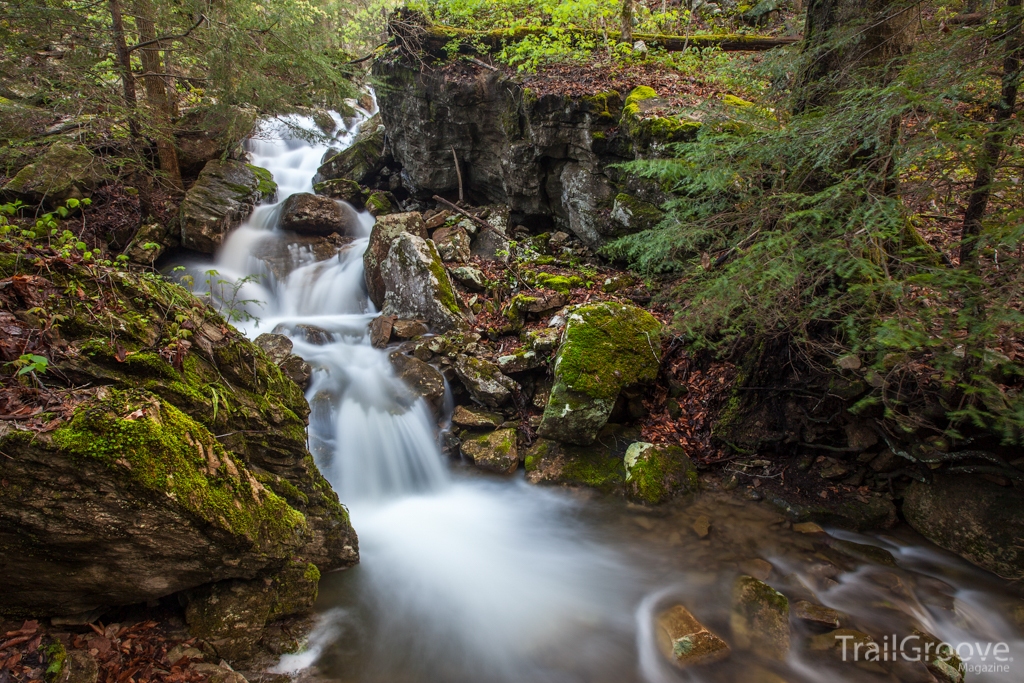
The Fiery Gizzard Trail stands as Tennessee's crown jewel of hiking destinations, earning recognition from Backpacker Magazine as one of America's top 25 trails. Located within South Cumberland State Park near Tracy City, this legendary 12.5-mile trail system offers an unparalleled wilderness experience that challenges even seasoned hikers while rewarding them with some of the most spectacular scenery in the Southeast.
What sets the Fiery Gizzard Trail apart from other Tennessee hiking destinations is its incredible diversity of terrain. In a single journey, you'll navigate through ancient hemlock groves, scramble across house-sized boulders, discover hidden waterfalls, and emerge onto breathtaking overlooks that stretch for miles across the Cumberland Plateau. The trail's unique geology creates a constantly changing landscape that keeps hikers engaged from start to finish.
The trail's distinctive name has fascinating origins rooted in local history. The "Gizzard" portion comes from the gizzard shad fish that once populated Fiery Gizzard Creek, while "Fiery" refers to the creek's former turbulence through the rocky gorge. This rich historical context adds depth to your hiking experience, connecting you to the generations of people who have explored these ancient lands.
Trail Difficulty Reality Check
Don't let the moderate 9.8-mile distance fool you. The Fiery Gizzard Trail is genuinely challenging, featuring 2-3 miles of technical rock scrambling that can slow progress to 1 mile per hour. Many experienced hikers rate this as more difficult than longer trails in the Smokies due to the demanding terrain.
Route Options & Navigation
The Fiery Gizzard Trail offers several routing options to accommodate different skill levels and time constraints. Understanding these choices is crucial for planning a successful adventure that matches your abilities and goals.
Raven's Point Loop (Recommended)
- Distance: 9.8 miles
- Difficulty: Strenuous
- Highlights: Technical rock scramble, Raven's Point overlook, waterfalls
- Best for: Experienced hikers seeking a challenging day hike
Full Trail (Tracy City to Foster Falls)
- Distance: 12.5 miles one-way
- Difficulty: Very Strenuous
- Highlights: Complete trail experience, Foster Falls finale
- Best for: Backpackers or shuttle arrangements
Counterclockwise vs. Clockwise: The Great Debate
After hiking the Fiery Gizzard Trail in both directions multiple times, I strongly recommend the counterclockwise approach for the loop trail. This strategy tackles the notorious boulder field early when your energy and focus are at peak levels. The technical rock scrambling section becomes significantly more dangerous when attempted with tired legs and waning daylight.
The counterclockwise route allows you to experience the dramatic gorge scenery first, including Blue Hole Falls and Sycamore Falls, before ascending the challenging rock scramble to Raven's Point. Your return journey via the Dog Hole Trail provides easier terrain and beautiful ridge-top views, making for a more enjoyable finish to your adventure.
Experience the trail's highlights through this comprehensive video guide
Essential Gear & Equipment

Proper gear selection can make the difference between an epic adventure and a dangerous struggle on the Fiery Gizzard Trail. The technical terrain and remote location demand equipment that can handle challenging conditions while keeping you safe and comfortable throughout your journey.
Footwear: Your Foundation for Success
The rocky, often slippery terrain of the Fiery Gizzard Trail demands robust hiking boots with excellent ankle support and aggressive tread patterns. I've witnessed numerous hikers struggle with inappropriate footwear, leading to twisted ankles and uncomfortable experiences on the boulder fields.

Columbia Newton Ridge Plus II Waterproof
Excellent ankle support and waterproof protection make these boots ideal for the Fiery Gizzard Trail's demanding conditions.
Check Price on AmazonTrekking Poles: Stability on Technical Terrain
While some experienced scramblers prefer hiking without poles through the boulder field, I recommend bringing adjustable trekking poles for the non-technical sections. They provide valuable stability during stream crossings and help reduce stress on knees during the steep descents.

Cascade Mountain Tech Aluminum Trekking Poles
Lightweight, durable, and featuring quick-lock adjustments perfect for variable terrain on the trail.
Check Price on AmazonHydration: Critical for Success
The strenuous nature of the Fiery Gizzard Trail demands serious attention to hydration. I recommend carrying 2-3 liters of water per person, or bringing a reliable water filtration system to refill from the pristine mountain streams along the route.
Hydration Pack Option
Lightweight hydration backpack with 2L water bladder for hands-free drinking during technical sections.
View on AmazonWater Filter Option
LifeStraw Personal Water Filter for safe drinking from natural water sources along the trail.
View on AmazonPro Gear Tips from My Experience
- Bring duct tape - I've seen multiple hikers' boot soles separate on the rocky terrain
- Pack a headlamp even for day hikes - the technical sections slow progress significantly
- Consider quality trail boots over lightweight shoes for ankle protection
- GPS device or smartphone with offline maps as backup navigation
My Personal Trail Experience
My first encounter with the Fiery Gizzard Trail came during a crisp October morning five years ago, and it remains one of the most transformative hiking experiences of my life. What started as confidence quickly evolved into humble respect for this demanding trail as I found myself questioning every step through the infamous boulder field.

The initial descent from the Grundy Forest trailhead felt deceptively easy, winding through the peaceful Day Loop section past Blue Hole Falls. The ancient hemlock trees created a cathedral-like atmosphere that made me feel connected to something much larger than myself. However, this meditative beginning didn't prepare me for what lay ahead in the gorge.
Once I crossed the wooden bridge and committed to the Fiery Gizzard Trail proper, the character completely changed. The boulder field that defines this trail's reputation stretched ahead like a challenging puzzle, each step requiring careful consideration of foot placement and balance. Progress slowed to barely one mile per hour as I navigated house-sized rocks, some slick with moisture from nearby waterfalls.
Lessons Learned from Multiple Visits
Through subsequent hikes during different seasons, I've learned that timing significantly impacts the Fiery Gizzard Trail experience. My spring visits revealed spectacular wildflower displays, including rare pink lady's slippers hidden near the creek confluence. Fall expeditions provided stunning autumn colors but also taught me about the dangers of wet leaves on already slippery rocks.
Rangers at South Cumberland State Park consistently emphasize the importance of proper preparation, and I've witnessed firsthand why their warnings shouldn't be taken lightly. During one memorable summer hike, I encountered a group of underprepared hikers who had underestimated both the difficulty and water requirements, leading to a concerning situation that required assistance.
Real Hiker Reviews from the Trail Community
"Absolutely stunning trail but don't underestimate the difficulty. The boulder section is no joke - took us 6 hours total and we're experienced hikers. Raven's Point view made every challenging step worth it."
- Sarah M., AllTrails Review
"Did this trail counterclockwise as recommended and glad we did. The rock scrambling at the beginning was tough but manageable. Coming back on Dog Hole Trail was much more pleasant. Definitely bringing more water next time!"
- Mike R., Reddit r/hiking
"One of Tennessee's premier trails for good reason. The waterfalls, rock formations, and final overlook create an incredible wilderness experience. Just be prepared for a real workout - this isn't a casual day hike."
- Jennifer L., TripAdvisor
The psychological challenge of the trail shouldn't be underestimated either. There were moments during my first hike when the seemingly endless boulder field tested my mental fortitude as much as my physical capabilities. However, reaching Raven's Point and gazing out across the vast Cumberland Plateau wilderness provided a profound sense of accomplishment that has kept me returning year after year.
Safety Tips & Best Practices
Safety on the Fiery Gizzard Trail requires more attention than typical hiking destinations due to the technical terrain and remote location. Understanding potential hazards and implementing proper precautions can prevent dangerous situations and ensure an enjoyable experience.
Primary Hazards
- Slippery rock surfaces, especially when wet
- Unstable boulder movement during scrambles
- Venomous snakes (copperheads, timber rattlers)
- Flash flood potential in gorge sections
- Getting lost in poorly marked boulder field
Safety Best Practices
- Start early (sunrise) to ensure daylight finish
- Inform someone of your hiking plans
- Check weather conditions thoroughly
- Carry first aid kit and emergency whistle
- Download offline maps before departure
Weather Considerations
Weather significantly impacts safety on the Fiery Gizzard Trail. Rain makes the already challenging rock surfaces extremely treacherous, while winter conditions can create dangerous ice formations. I've learned to be extremely conservative with weather decisions - it's better to postpone your hike than risk injury on slippery surfaces.
The trail's location in the gorge also creates microclimates that can differ significantly from weather forecasts. I've experienced sudden temperature drops of 10-15 degrees when descending into the shaded gorge areas, making layered clothing essential even during warmer months.
Emergency Preparedness
Cell phone coverage is spotty throughout much of the Fiery Gizzard Trail, particularly in the gorge sections. Consider bringing a satellite communicator for emergencies, especially if hiking alone. The nearest hospital is in Winchester, approximately 45 minutes from the trailhead.
For related safety gear recommendations, check out our guides on proper trail shoes and challenging trail preparation.
Trail Navigation Tips
The boulder field section of the Fiery Gizzard Trail presents unique navigation challenges where the actual trail disappears beneath massive rocks. White blazes mark the official route, but they can be difficult to spot when you're focused on careful foot placement. I recommend stopping regularly to look ahead for the next blaze before committing to your path.
Pros and Cons: Honest Assessment
What Makes This Trail Outstanding
- Incredible diversity of terrain and scenery
- Spectacular waterfalls and swimming holes
- Legitimate wilderness experience close to cities
- Well-maintained trail system with good facilities
- Rich historical and cultural significance
- Excellent wildlife viewing opportunities
Potential Drawbacks to Consider
- Extremely challenging technical terrain
- Can be dangerous in wet conditions
- Very popular, especially on weekends
- Limited bailout options once committed
- Requires significant physical preparation
- Not suitable for inexperienced hikers
The Fiery Gizzard Trail represents the gold standard for challenging day hikes in the Southeast, but it's not for everyone. Consider exploring easier options like the Watchman Trail or Chimney Tops Trail to build experience before tackling this demanding adventure.
Conclusion
The Fiery Gizzard Trail stands as Tennessee's premier hiking challenge, offering an unparalleled wilderness experience that tests both physical abilities and mental resolve. This legendary trail delivers everything serious hikers seek: technical challenges, stunning natural beauty, rich history, and the profound satisfaction that comes from conquering one of the Southeast's most demanding adventures.
While the Fiery Gizzard Trail demands respect, proper preparation, and considerable physical fitness, the rewards justify every challenging step. From the peaceful beginning at Blue Hole Falls through the grueling boulder field to the triumphant summit at Raven's Point, this trail creates memories that last a lifetime and stories you'll share for years to come.
Whether you choose the full 12.5-mile end-to-end adventure or the popular 9.8-mile loop, the Fiery Gizzard Trail will challenge your limits while showcasing Tennessee's most spectacular wilderness scenery. Just remember to respect the trail, prepare thoroughly, and always prioritize safety over summit goals.
Ready to Explore More Epic Trails?
Discover comprehensive guides to America's most incredible hiking destinations, complete with detailed route descriptions, gear recommendations, and insider tips.
Explore More Trails Continental Divide TrailFrequently Asked Questions
How difficult is the Fiery Gizzard Trail?
The Fiery Gizzard Trail is considered one of Tennessee's most challenging hikes, rated as strenuous due to extensive rock scrambling, technical terrain, and significant elevation changes. The trail features approximately 2-3 miles of boulder hopping that requires careful foot placement and good balance. Most experienced hikers find this more demanding than longer trails in the Smokies due to the technical nature of the terrain. Physical fitness, proper gear, and mental preparation are essential for success.
What's the best time of year to hike Fiery Gizzard Trail?
The optimal hiking seasons are spring (April-May) for wildflowers and waterfalls, and fall (October-November) for stunning autumn colors. Spring offers spectacular wildflower displays including rare pink lady's slippers, while fall provides comfortable temperatures and breathtaking foliage. Summer can be hot and humid with increased snake activity, while winter may present icy conditions on the rocky sections. Consider exploring other seasonal trails like the Sliding Sands Trail during extreme weather periods.
Should I hike the Fiery Gizzard Trail clockwise or counterclockwise?
Most experienced hikers recommend going counterclockwise, tackling the challenging rock scramble section first when you have the most energy. This route gets the difficult terrain out of the way early and provides easier hiking on the return via Dog Hole Trail. The technical boulder field becomes significantly more dangerous when attempted with tired legs and waning daylight. Starting counterclockwise also allows you to experience the dramatic gorge scenery and waterfalls first, building excitement for the challenging climb ahead.
How long does it take to complete the Fiery Gizzard Trail?
The full loop to Raven's Point typically takes 5-7 hours for most hikers, depending on fitness level, trail conditions, and time spent at viewpoints. The challenging boulder sections significantly slow progress, often reducing speed to 1 mile per hour through technical areas. Factor in extra time for photography, rest breaks, and potentially getting temporarily off-route in the boulder field. Starting at sunrise is recommended to ensure completion before dark, especially during shorter winter days.
Do I need special gear for the Fiery Gizzard Trail?
Essential gear includes sturdy hiking boots with good ankle support, plenty of water (2-3 liters), snacks, first aid kit, and possibly trekking poles for stability. The rocky terrain demands quality footwear to prevent injuries - many hikers recommend women's trail boots or specialized trail boots for maximum protection. Additional recommended items include duct tape for emergency boot repairs, headlamp for early starts or delayed finishes, GPS device or smartphone with offline maps, and weather-appropriate layers for changing conditions.