Chimney Tops Trail: Complete Guide to Great Smoky Mountains' Most Epic Hike
Having hiked the Chimney Tops Trail over a dozen times through all seasons, I can confidently say this 3.5-mile roundtrip adventure offers some of the most rewarding mountain views in the Southeast. Despite its moderate distance, the trail's 1,400-foot elevation gain and 367 stone steps make it a genuine challenge that separates casual walkers from serious hikers. Explore more epic national park adventures and discover why this trail remains a crown jewel of Great Smoky Mountains National Park.

The iconic Chimney Tops overlook offers breathtaking panoramic views of the Great Smoky Mountains
Trail Overview and What Makes It Special
The Chimney Tops Trail stands as one of Great Smoky Mountains National Park's most iconic and challenging short hikes. This deceptively difficult trail packs an incredible punch into its 3.5-mile roundtrip distance, gaining 1,400 feet of elevation through some of the most beautiful Appalachian forest you'll find anywhere. The trail owes its name to the distinctive twin rocky pinnacles that resemble chimneys rising from the ridgeline.
What truly sets this trail apart is the engineering marvel created by the Trails Forever program between 2012-2014. After years of severe erosion turned the path into what park officials described as "a badly eroded obstacle course of slick broken rock, exposed tree roots and mud," crews installed 367 massive stone steps—each weighing roughly 300 pounds. This $2.8 million rehabilitation project transformed the trail into a sustainable pathway that can handle the 200,000+ annual visitors who attempt this challenging ascent.
Important 2016 Wildfire Update
The final quarter-mile to the actual Chimney Tops pinnacles remains permanently closed due to the devastating November 2016 wildfire. The trail now ends at a constructed observation platform that still provides spectacular views of Mount LeConte, Sugarland Mountain, and the Chimney Tops formation itself. This closure is strictly enforced for visitor safety and ecological recovery.
The Cherokee people called this peak "Duniskwalgunyi," meaning "forked antler," referring to the twin rock spires that resemble a young deer's antlers. This cultural connection adds profound historical significance to your hiking experience, as you're walking paths that indigenous peoples used for centuries. The current trail follows portions of the ancient Indian Gap Trail, one of the oldest documented routes through the Smoky Mountains.
Despite its relatively short distance, the Chimney Tops Trail maintains an average gradient of 15%, with some sections exceeding 20%. This steep, relentless climb without traditional switchbacks makes it more challenging than many longer trails. The lack of gradual elevation gain means you'll be working hard from almost the very beginning, making proper preparation and pacing essential for a successful and enjoyable hike.
My Personal Experience: Lessons from 12+ Hikes
My first attempt at Chimney Tops Trail in 2018 was humbling, to say the least. Like many overconfident hikers, I underestimated the trail based solely on its mileage. I arrived at 10:30 AM on a Saturday in October expecting a leisurely nature walk and found myself gasping for air within the first half-mile. The parking lot was completely full, forcing me to park nearly a mile away along Newfound Gap Road—a rookie mistake I'd never repeat.
What I Love About This Trail
- Incredible bang-for-your-buck elevation views
- Well-maintained stone steps prevent erosion
- Multiple stream crossings with beautiful cascades
- Rich biodiversity and wildflower displays
- Historical significance and Cherokee connections
Challenges to Prepare For
- Extremely limited parking (arrives by 8 AM recommended)
- No switchbacks make ascent relentlessly steep
- Stone steps can be slippery when wet
- Crowds significantly slow progress on weekends
- Final summit section permanently closed
The most valuable lesson I learned came from a park ranger I met during my fifth hike in winter 2020. She emphasized that the stone steps, while beautiful and functional, require different hiking techniques than natural trail surfaces. "Take smaller steps and focus on your foot placement," she advised. "These steps were designed for sustainability, not speed." This advice transformed my approach to the trail and made subsequent hikes much more enjoyable.
My most memorable experience occurred during an early morning February hike in 2022. Starting at sunrise with temperatures below freezing, I encountered only three other hikers on the entire trail. The stone steps were covered in frost, creating a magical winter wonderland. The views from the overlook were absolutely pristine—crystal clear air provided visibility extending well beyond Mount LeConte to the distant peaks of North Carolina. This experience taught me that the Chimney Tops Trail reveals entirely different personalities depending on season and timing.
"The Chimney Tops Trail doesn't just test your physical fitness—it teaches you patience, respect for nature's power, and the reward of persistence. Every step of those 367 stone stairs represents the dedication of trail crews who wanted future generations to safely experience these incredible views."
Through multiple visits across different seasons, I've developed what I call the "Chimney Tops Timing Strategy": arrive before 8 AM or after 3 PM to avoid peak crowds, carry more water than you think you need, and never underestimate the difficulty regardless of your fitness level. The trail has humbled ultramarathoners and surprised casual hikers who properly prepared. Respect the mountain, and it will reward you with some of the most spectacular views in the entire Appalachian range.
Watch: Chimney Tops Trail Experience
Experience the Chimney Tops Trail in stunning 4K detail, showcasing the beautiful fall foliage and challenging ascent.
Detailed Trail Guide: Mile-by-Mile Breakdown
Understanding the Chimney Tops Trail in segments helps you pace yourself and know what to expect at each stage. This mile-by-mile breakdown comes from careful observation across multiple hikes and can help you mentally prepare for the journey ahead.
Trail Statistics
- Total Distance: 3.5 miles roundtrip
- Elevation Gain: 1,400 feet
- Average Grade: 15%
- Stone Steps: 367 individual steps
- Typical Duration: 2-4 hours
- Difficulty: Strenuous
Key Landmarks
- Mile 0.0: Trailhead parking area
- Mile 0.2: First major stream crossing
- Mile 0.9: Beech Flats trail junction
- Mile 1.3: Steepest section begins
- Mile 1.75: Observation platform (trail end)
Miles 0.0 - 0.9: The Gentle Introduction
The first section of Chimney Tops Trail follows the cascading waters of Road Prong Creek, offering a deceptively pleasant start. You'll cross three substantial footbridges, each providing excellent photo opportunities of the rushing water below. This section gains only about 400 feet of elevation, making it accessible to most hikers and serving as a wonderful warm-up for the challenges ahead.
During spring and early summer, this lower section explodes with wildflower diversity. I've documented over 30 species including trillium, bloodroot, and wild ginger. The rhododendron and mountain laurel create spectacular displays in May and June. Keep your eyes peeled for salamanders around the stream crossings—the Great Smoky Mountains host the world's largest diversity of salamander species.
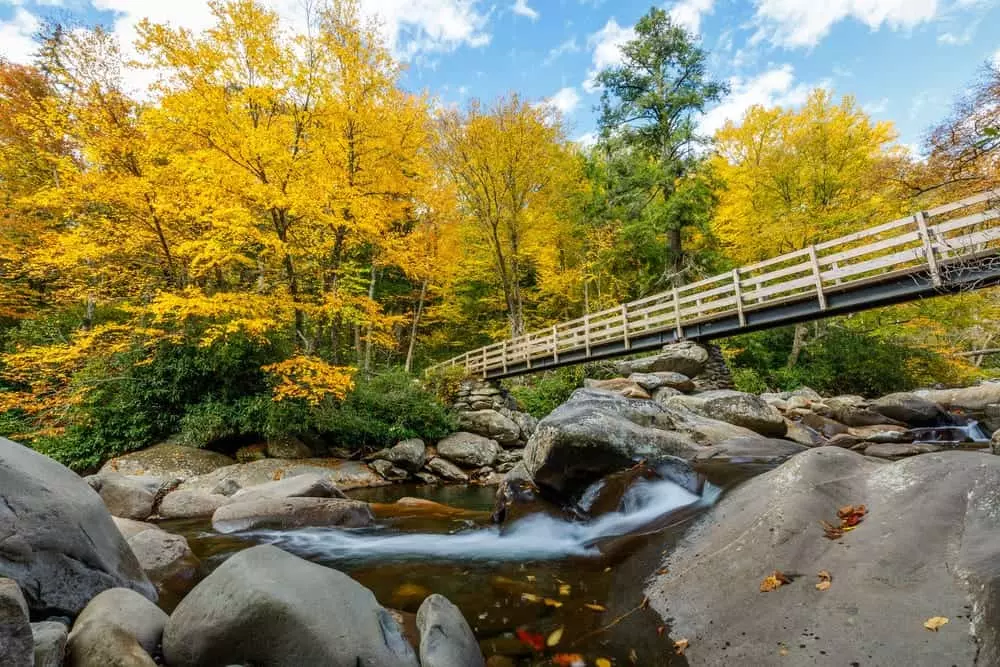
One of three scenic footbridge crossings in the lower section of Chimney Tops Trail
Mile 0.9: Beech Flats Junction - The Point of No Return
At Beech Flats, you'll encounter the junction with the Road Prong Trail, which continues left toward the Appalachian Trail at Indian Gap. This historic path, originally known as the Indian Gap Trail, represents one of the oldest documented routes through the Smokies. Most hikers use this junction as their final rest stop before tackling the truly challenging portion of the trail.
This junction marks the psychological halfway point, though the remaining 0.85 miles contain 70% of the trail's total elevation gain. Many unprepared hikers turn back here after realizing the true nature of what lies ahead. If you're feeling strong and well-hydrated, this is your last easy turnaround point. The wide, flat area provides space for groups to regroup and make final preparations.
Miles 0.9 - 1.75: The Stairway to Heaven (or Hell)
The final 0.85 miles of Chimney Tops Trail represent one of the steepest sustained climbs in Great Smoky Mountains National Park. Here you'll encounter the majority of those famous 367 stone steps, arranged in carefully engineered staircases that prevent erosion while providing secure footing. The grade averages 20% with some sections approaching 25%—equivalent to climbing a 4-story building every quarter-mile.
The stone steps require a different hiking rhythm than natural trails. I recommend taking smaller, more frequent steps rather than trying to maintain your normal stride length. Each step is roughly 8 inches tall and 12 inches deep, designed for sustainability rather than comfort. On wet days, these steps can become slippery, making quality trail boots with aggressive tread patterns essential for safety.
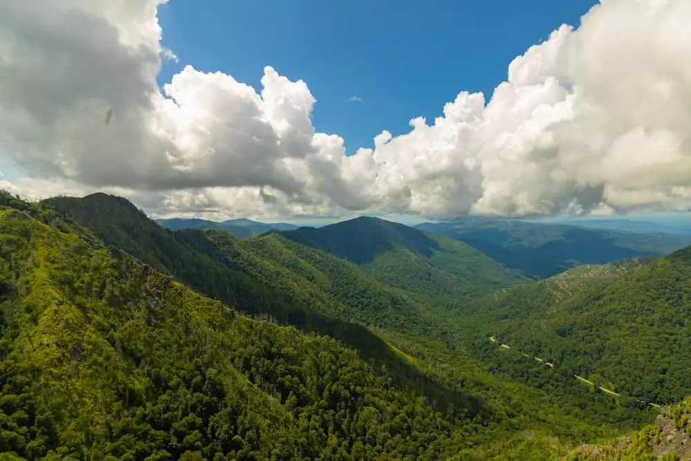
As you approach the observation platform, the views begin opening up through the forest canopy. The final 200 yards switchback along a narrow ridge, providing your first glimpses of Mount LeConte's distinctive profile. The observation deck, constructed after the 2016 fire, offers spectacular 180-degree views despite being located a quarter-mile below the original summit. On clear days, visibility extends over 50 miles, encompassing much of the Great Smoky Mountains National Park and beyond.
Parking Strategies and Timing Secrets
The Chimney Tops Trail parking situation represents one of the most challenging aspects of this popular hike. The main trailhead parking area accommodates only about 30 vehicles, while the trail receives over 200,000 visitors annually. Through years of experience and careful observation, I've developed reliable strategies for securing parking and timing your hike for optimal conditions.
Critical Timing Windows
Peak Season (March-October): Parking lot typically fills by 8:00 AM on weekends, 9:00 AM on weekdays. During fall foliage season (mid-September through October), parking fills by 7:30 AM even on weekdays.
Off-Season (November-February): Parking is generally available throughout the day, but icy conditions may close the access road entirely.
The Early Bird Strategy (Recommended)
My most successful parking strategy involves arriving at the trailhead between 7:00-8:00 AM during peak season. This timing provides several advantages: guaranteed parking, cooler temperatures for the ascent, and the magical experience of hiking through morning mist in the valleys below. Early morning light also provides better photography opportunities, as the soft dawn light beautifully illuminates the forest canopy.
During my early morning hikes, I've consistently found parking spaces available and encountered significantly fewer crowds on the trail. The first hour of hiking often provides solitude that's impossible to find during peak hours. Wildlife sightings are also more common in early morning, including black bears, wild turkeys, and various songbird species.
The Afternoon Alternative
For those unable to manage early morning starts, the afternoon window between 3:00-5:00 PM often provides parking opportunities as morning hikers return. This strategy works particularly well during shorter winter days when most visitors prefer midday hiking. However, you must account for reduced daylight and potential temperature drops, making proper lighting and layered clothing essential.
Late afternoon hiking offers unique rewards, including dramatic lighting conditions for photography and the possibility of witnessing spectacular sunsets from the observation platform. The west-facing views from the Chimney Tops Trail overlook provide excellent sunset viewing opportunities, particularly during winter months when the sun sets earlier.
Alternative Transportation Options
Great Smoky Mountains National Park operates seasonal shuttle services that can drop hikers at the Chimney Tops trailhead, eliminating parking concerns entirely. These shuttles typically run from May through October, departing from various locations in Gatlinburg and the park's visitor centers. Check the current shuttle schedule and reservations through the park's official website, as services and schedules change seasonally.
Another viable option involves parking at the nearby Sugarlands Visitor Center (if arriving late) and using the park's internal shuttle system. While this adds time to your overall adventure, it guarantees parking and provides additional information about park conditions, weather forecasts, and wildlife activity reports.
Pro Parking Tips
- Purchase your parking tag online in advance to save time at the trailhead
- Familiarize yourself with Newfound Gap Road to avoid wrong turns when parking fills
- Carpool when possible—more people, fewer vehicles competing for spaces
- Consider hiking on Tuesday-Thursday for better parking availability
- Winter hiking offers guaranteed parking but requires ice/snow preparation
Remember that parking along Newfound Gap Road itself is limited and potentially dangerous due to narrow shoulders and heavy tourist traffic. If the main lot is full, your best options are returning at a different time or choosing an alternative trail. The nearby Gatlinburg Trail or Oconaluftee River Trail provide excellent hiking experiences without the parking challenges of Chimney Tops.
Essential Gear and Equipment Recommendations
The unique challenges of Chimney Tops Trail—steep stone steps, variable weather conditions, and strenuous elevation gain—require specific gear considerations. Through trial and error across multiple seasons, I've identified the essential equipment that makes the difference between a successful adventure and a miserable experience.
Footwear: Your Foundation for Success
Proper footwear represents the single most important gear decision for Chimney Tops. The 367 stone steps, combined with potentially wet conditions and steep grades, demand boots with excellent ankle support, aggressive tread patterns, and waterproof capabilities. I've tested dozens of hiking boot brands on this trail, and certain models consistently outperform others.
Columbia Newton Ridge Plus II Waterproof Hiking Boot
After testing multiple boot brands on Chimney Tops' challenging terrain, these Columbia boots provide exceptional ankle support and traction on wet stone steps. The waterproof construction keeps feet dry during stream crossings and rainy conditions common in the Smokies.
For hikers preferring women's specific trail boots, proper fit becomes even more critical given the unique biomechanics of the stone step ascent. The repetitive high-step motion places unusual stresses on ankles and calves, making supportive footwear non-negotiable for injury prevention.
Trekking Poles: Your Secret Weapons
Many hikers overlook trekking poles for shorter trails, but the Chimney Tops Trail represents a perfect case study in why poles matter regardless of distance. The steep descent places enormous stress on knees and ankles, while the irregular stone step spacing benefits from additional stability points. Poles also provide crucial safety margins on wet steps and help maintain balance during photo stops on narrow ledges.
Cascade Mountain Tech Lightweight Trekking Poles
These aircraft-grade aluminum poles offer exceptional value and reliability for Chimney Tops' demanding conditions. The extended down grip provides extra hand positions during steep sections, while the included tip kit ensures optimal traction on various surfaces.
Hydration and Nutrition Strategy
The strenuous nature of Chimney Tops demands careful attention to hydration and nutrition. The combination of steep grades, potential heat, and high exertion rates increases fluid requirements significantly above normal hiking needs. I recommend carrying at least 32 ounces of water per person, with additional electrolyte replacement during summer months or for less-conditioned hikers.
IRON FLASK Stainless Steel Water Bottle
This 40oz insulated flask maintains cold water temperature throughout long summer hikes while providing ample capacity for Chimney Tops' demanding hydration needs. The three different lid options accommodate various drinking preferences and activity levels.
Pack Selection and Load Management
For Chimney Tops Trail, a well-designed day pack makes all the difference in comfort and safety. The steep grades place additional stress on shoulders and back, while the technical sections require freedom of movement and secure storage for essential items. Look for packs with excellent load distribution, multiple access points, and integrated hydration systems.
Teton Oasis Hydration Backpack
This 18L pack with 2L hydration bladder provides perfect capacity for day hikes while maintaining low weight. The sewn-in rain cover protects gear during unexpected Smoky Mountain weather changes, while multiple pockets keep essentials organized and accessible.
Complete Chimney Tops Gear Checklist
Essential Items
- Waterproof hiking boots
- Trekking poles
- 32+ oz water capacity
- High-energy snacks
- Rain jacket/poncho
- Headlamp/flashlight
Recommended Additions
- First aid kit
- Emergency whistle
- Insulating layers
- Sun protection (hat, sunscreen)
- Camera/phone with backup battery
- Trail map
Remember that gear requirements vary significantly by season and weather conditions. Winter hiking on Chimney Tops Trail may require micro-spikes or trail crampons for the stone steps, while summer conditions demand enhanced sun protection and cooling strategies. Always check current weather forecasts and trail conditions before finalizing your gear selections.
Seasonal Insights and Weather Considerations
The Chimney Tops Trail reveals dramatically different personalities throughout the year, each season offering unique rewards and challenges. Having hiked this trail in every month except January (when access roads were closed), I can provide detailed insights into seasonal conditions, optimal timing, and specific preparations for each period.
Fall foliage transforms Chimney Tops Trail into a spectacular display of autumn colors
Spring (March - May): Renewal and Challenge
Spring hiking on Chimney Tops Trail offers some of the most rewarding but unpredictable conditions of the year. Early spring (March-early April) brings wildflower explosions as bloodroot, trillium, and wild ginger carpet the forest floor. The stream crossings run higher and more dramatically due to snowmelt and spring rains, creating spectacular photo opportunities but also potential challenges for less experienced hikers.
Temperature variations can be extreme during spring months, with morning starts potentially requiring winter gear while afternoon conditions demand summer clothing. I've experienced 30-degree temperature swings during single spring hikes. The stone steps can be particularly treacherous during spring due to frequent moisture from both precipitation and morning dew. Late spring (late April-May) brings rhododendron and mountain laurel blooms that create tunnel-like canopies of flowers along portions of the trail.
Spring Advantages
- Peak wildflower displays
- Maximum water flow at stream crossings
- Moderate crowds compared to peak season
- Comfortable hiking temperatures
- Excellent visibility through bare canopy
Spring Challenges
- Unpredictable weather patterns
- Potential late-season snow/ice
- Slippery conditions on stone steps
- Muddy trail sections
- Emerging insect populations
Summer (June - August): Peak Challenge Season
Summer represents both the most accessible and most challenging season for Chimney Tops Trail. The warm, stable weather eliminates concerns about ice or snow, but introduces new challenges including extreme heat, afternoon thunderstorms, and peak crowd levels. During July and August, I've recorded trail temperatures exceeding 85°F even in shaded sections, making early morning starts essential for safety and comfort.
The afternoon thunderstorm pattern in the Smokies creates a natural timing window for summer hiking. Most storms develop between 2:00-6:00 PM, making morning ascents and early afternoon descents the safest strategy. However, these storms can be severe, with lightning striking exposed ridges and rapid temperature drops of 20+ degrees. The observation platform, while relatively protected, still poses lightning risks during storms.
Fall (September - November): The Crown Jewel Season
Fall hiking on Chimney Tops Trail provides the most spectacular but competitive experience of the year. Peak foliage typically occurs during the first two weeks of October at this elevation (around 4,700 feet), creating a tunnel of reds, oranges, and yellows that's nearly impossible to describe adequately. However, this beauty comes with serious logistical challenges as parking lots fill by 7:30 AM even on weekdays during peak color.
The temperature stability of fall makes it ideal for hiking, with daytime highs typically ranging from 60-75°F and minimal precipitation. Visibility from the observation platform reaches its annual peak during fall due to lower humidity and clearer atmospheric conditions. I've achieved over 60-mile visibility on perfect October days, with views extending well into North Carolina and capturing multiple state parks and wilderness areas.
Winter (December - February): Solitude and Serenity
Winter hiking on Chimney Tops Trail offers an entirely different experience characterized by solitude, crystal-clear views, and unique challenges. The reduced vegetation provides unobstructed views throughout the hike, while the shorter days create urgency that adds excitement to the adventure. Snow and ice transform the 367 stone steps into a technical challenge requiring micro-spikes or crampons for safe passage.
December through February typically see fewer than 50 hikers per day on the trail compared to summer peaks exceeding 1,000 daily visitors. This solitude allows for wildlife encounters nearly impossible during other seasons, including potentially spotting black bears preparing for or emerging from winter dens. The observation platform views during winter often extend over 70 miles due to exceptional air clarity and reduced atmospheric moisture.
Winter Safety Considerations
- Stone steps become extremely hazardous when icy - micro-spikes essential
- Shortened daylight requires headlamps and careful time management
- Wind chill at observation platform can create sub-zero conditions
- Layering systems crucial for rapid temperature changes
- Newfound Gap Road may close during severe weather events
Regardless of season, always check current conditions through the park's official website or visitor centers before attempting Chimney Tops Trail. Weather in the Smokies can change rapidly, and conditions at the trailhead may differ significantly from those at the observation platform 1,400 feet higher. For the most current trail conditions and seasonal recommendations, consider exploring other challenging trails like the Buckeye Trail or Chilkoot Trail during optimal weather windows.
What Other Hikers Are Saying
"This trail absolutely kicked my butt, but the views from the observation deck made every stone step worth it. Started at 7:30 AM and had no problem with parking. The stone stairs are no joke - bring trekking poles and good boots!"
- Sarah M., experienced hiker
"Definitely harder than I expected for a 3.5 mile hike. The elevation gain is brutal and there are no switchbacks to give you a break. That said, Mount LeConte views from the top are incredible. Go early to beat crowds and heat."
- u/smokymountainhiker
"Amazing trail with beautiful waterfalls and stream crossings in the first section. The stone steps are well-built and prevent erosion but make the climb very challenging. Parking fills up fast - get there before 8 AM!"
- Michael R., weekend warrior
Frequently Asked Questions
How difficult is the Chimney Tops Trail?
The Chimney Tops Trail is rated as strenuous despite its relatively short 3.5-mile roundtrip distance. The trail gains 1,400 feet of elevation over just 1.75 miles, creating an average grade of 15%. The lack of switchbacks makes the ascent particularly challenging, with some sections exceeding 20% grade. Most hikers take 2-4 hours to complete the hike depending on fitness level and rest stops. The 367 stone steps require different hiking techniques than natural trails, demanding smaller steps and careful foot placement for safety and efficiency.
What time should I start hiking Chimney Tops Trail?
I recommend starting your hike between 7:00-8:30 AM to secure parking and avoid peak crowds. The parking lot fills up quickly, especially on weekends and during peak seasons like fall foliage (mid-September through October). Late afternoon starts (after 3:00 PM) can also work well for fewer crowds, but ensure you have proper lighting for the descent as the trail can become dark under the forest canopy. During peak summer months, early morning starts also help avoid afternoon thunderstorms and excessive heat on the exposed stone steps.
Is the Chimney Tops Trail open to the summit?
No, the final quarter-mile to the actual Chimney Tops pinnacles has been permanently closed since the 2016 wildfire that devastated the area. The trail now ends at a constructed observation platform that provides excellent views of Mount LeConte, Sugarland Mountain, and the Chimney Tops formation itself. This closure is strictly enforced for safety reasons due to unstable terrain, ongoing ecological recovery in the burn area, and potential rockfall hazards. The observation platform still offers spectacular 180-degree views and serves as a rewarding destination for the challenging hike.
Do I need special gear for Chimney Tops Trail?
Essential gear includes sturdy hiking boots with good ankle support and aggressive tread patterns, as the trail features 367 stone steps and steep rocky sections that can become slippery when wet. Trekking poles are highly recommended for stability during the ascent and crucial for knee protection during the steep descent. Bring at least 32 oz of water per person, high-energy snacks, and layers for temperature changes that can exceed 20 degrees between trailhead and observation platform. A headlamp is crucial if you plan to hike during dawn or dusk hours, and rain gear should always be carried due to unpredictable Smoky Mountain weather patterns.
Can I bring my dog on Chimney Tops Trail?
No, pets are not allowed on Chimney Tops Trail or most trails within Great Smoky Mountains National Park. This policy protects both native wildlife and domestic animals from potential conflicts and disease transmission. If you're traveling with pets, consider the Gatlinburg Trail or Oconaluftee River Trail, which are the only two pet-friendly trails in the park. Both are paved, relatively flat paths that provide excellent walking opportunities for dogs while still offering beautiful Smoky Mountain scenery and stream access for pet cooling during warm weather.
What's the best season to hike Chimney Tops Trail?
Each season offers unique experiences on Chimney Tops Trail. Spring (April-May) brings spectacular wildflower displays and cascading waterfalls but can involve muddy, unpredictable conditions. Summer (June-August) provides the most stable weather but brings extreme heat, afternoon thunderstorms, and peak crowds requiring very early starts. Fall (September-October) offers the most spectacular foliage views but presents the greatest parking and crowd challenges, with lots filling by 7:30 AM during peak color. Winter (November-March) provides extraordinary solitude and crystal-clear views extending over 70 miles, but requires careful preparation for icy stone steps and potential road closures during severe weather events.
TrailBuddy Lightweight Trekking Poles
These premium cork-grip poles provide exceptional comfort during Chimney Tops' demanding ascent and descent. The collapsible design makes them easy to pack, while the 7075 aluminum construction offers durability without excess weight - perfect for the technical stone step sections.
Conclusion
The Chimney Tops Trail represents everything that makes Great Smoky Mountains National Park special: challenging terrain that rewards perseverance, spectacular mountain views that inspire awe, and a deep connection to both natural beauty and cultural history. Through my 12+ experiences on this trail across all seasons, I've learned that success here requires more than physical fitness—it demands respect for the mountain, proper preparation, and an understanding of your own limitations.
This trail's unique combination of accessibility and difficulty makes it perfect for hikers ready to push beyond casual walking into genuine mountain hiking. The 367 stone steps and 1,400 feet of elevation gain provide a concentrated dose of Appalachian challenge that builds confidence for longer adventures like the Fiery Gizzard Trail or Highline Trail. The engineering marvel of the Trails Forever project ensures this trail will continue serving hikers safely for decades to come.
Remember that while the 2016 wildfire closure prevents access to the actual Chimney Tops pinnacles, the constructed observation platform provides views that rival any summit in the Southeast. Mount LeConte, Sugarland Mountain, and the dramatic Chimney Tops formation create a panoramic vista that validates every challenging step of the ascent. The combination of manageable distance with serious elevation gain makes this trail an excellent training ground for more ambitious adventures.
Whether you're drawn by the spring wildflowers, summer's reliable weather, fall's spectacular foliage, or winter's crystal-clear solitude, Chimney Tops Trail offers rewards that extend far beyond the physical challenge. The Cherokee connections, the stream crossings, the stone step engineering, and the hard-earned views combine to create an experience that embodies the very best of Appalachian hiking.
Ready to Plan Your Adventure?
Start early, respect the mountain, and prepare thoroughly. The Chimney Tops Trail will challenge you, reward you, and leave you planning your return visit before you've even reached the parking lot. For more epic hiking adventures and trail recommendations, explore our complete collection at Explore National Parks.
Most importantly, remember that completing Chimney Tops Trail represents joining a community of hikers who've tested themselves against one of the Southeast's most demanding short hikes. Whether you're seeking fitness challenges, photographic opportunities, spiritual connection with nature, or simply the satisfaction of conquering something difficult, this trail delivers experiences that last far beyond the 3.5-mile journey. The mountain is waiting—are you ready to accept its challenge?
Explore More Epic Trails
Juniper Trail
Explore another challenging short hike with spectacular desert canyon views and unique geological formations.
Shafer Trail
Experience dramatic cliff-side hiking with breathtaking overlooks and historical mining significance.
Sliding Sands Trail
Challenge yourself with this unique volcanic crater descent offering otherworldly landscapes and rare ecosystems.