Pohono Trail Yosemite: Complete Hiking Guide to the Valley's Hidden Rim Trail
After hiking Yosemite's Pohono Trail multiple times across different seasons, I can confidently say this 13-mile rim trail offers the most spectacular and diverse viewpoints of any single hike in the park. From my campsite perched 15 feet from Dewey Point's cliff edge to watching sunrise illuminate El Capitan, this trail transformed my understanding of Yosemite's grandeur. Whether you're planning a challenging day hike or an unforgettable backpacking adventure, this comprehensive guide shares everything I've learned from countless hours on this remarkable trail. Explore more national park adventures and discover why the Pohono Trail deserves a spot on every serious hiker's bucket list.
Trail Overview and Quick Facts
Trail Statistics
- Distance: 13 miles (21 km) one way
- Elevation Gain: 3,700 feet with Sentinel Dome
- Difficulty: Strenuous
- Hiking Time: 5-10 hours
- Season: Mid-May to early November
Why Hike the Pohono Trail?
This east-west traverse along Yosemite Valley's south rim delivers more spectacular viewpoints than any other single trail in the park. You'll experience bird's-eye views of Yosemite's most famous landmarks while enjoying relative solitude compared to the crowded valley floor trails.
The pohono trail represents Yosemite's ultimate rim walk, connecting Glacier Point to Tunnel View through a spectacular series of granite promontories. Unlike the valley's congested tourist magnets, this trail rewards committed hikers with unparalleled solitude and photography opportunities. During my multiple traversals of this route, I've consistently encountered fewer than two dozen people over the entire 13-mile distance, making it feel like a private tour of Yosemite's most dramatic vistas.
What sets the pohono trail apart from other Yosemite adventures is its comprehensive showcase of the valley's geological wonders. From a single hike, you'll witness every major waterfall, granite formation, and wilderness vista that defines this UNESCO World Heritage site. The trail's strategic positioning along the south rim provides optimal lighting conditions throughout the day, making it a photographer's paradise regardless of your departure time.
Pro Tip: Plan this hike during weekdays in shoulder seasons (late May or October) for maximum solitude and optimal weather conditions.
Planning Your Pohono Trail Adventure
Transportation Logistics
The biggest challenge of hiking the pohono trail isn't the physical demands—it's solving the transportation puzzle. With trailheads 16 miles apart by road, you'll need a solid plan for vehicle shuttling. After attempting various approaches over multiple trips, I've identified three reliable strategies that actually work in practice.
The two-car shuttle remains the gold standard for groups with multiple vehicles. Park one car at Glacier Point and another at Tunnel View, then shuttle your team to the preferred starting point. However, for solo hikers or single-vehicle groups, the Glacier Point tour bus offers a viable alternative, though timing and seat availability require careful planning.
Bus Transportation Details
- Departure times: 8:30 AM, 10 AM, 1:30 PM from Yosemite Lodge
- One-way tickets: $25 adults, $23 seniors, $15 children
- Return trip stops at Tunnel View only if schedule permits
- Reserve through Yosemite Lodge Tour Desk: (209) 372-1240
Permits and Regulations
Day hiking the pohono trail requires no permits, but backpacking demands advance wilderness permit reservations. With only 10 total overnight permits available, this trail books solid during peak season. I recommend securing reservations exactly 24 weeks in advance for summer dates, or consider shoulder season trips when first-come, first-served permits offer better availability.
The park's dispersed camping rules allow tremendous flexibility for backpackers willing to hike beyond the four-mile minimum distance. From my experience camping at Dewey Point, positioning your tent among the granite boulders provides wind protection while maintaining spectacular sunrise views of El Capitan and the surrounding wilderness.
Best Times
- Late May: Snow melted, waterfalls peak flow
- September: Clear weather, fewer crowds
- October: Fall colors, crisp air
Avoid These Times
- Early May: Lingering snow patches
- July-August: Extreme heat, crowds
- November: Road closures possible
Epic Viewpoints and Hidden Gems
The Big Six Viewpoints
The pohono trail connects six major viewpoints, each offering distinct perspectives of Yosemite Valley's granite amphitheater. Having photographed sunrise and sunset from multiple positions, I can confirm that each stop provides unique compositions impossible to capture from any other location in the park.
Glacier Point (Mile 0)
The iconic terminus featuring Half Dome's dramatic profile. Best for sunrise photography and pre-dawn departures.
Taft Point (Mile 2.5)
Featuring the famous fissures and unobstructed El Capitan views. Essential stop for cliff edge photography.
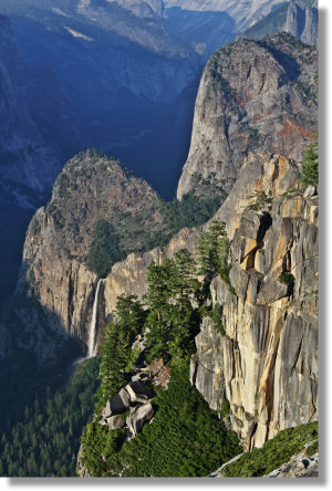
Dewey Point (Mile 5.1)
The crown jewel viewpoint with panoramic valley vistas. Perfect for camping and extended photography sessions.
Crocker Point (Mile 4.4)
Top-down perspective of Bridalveil Falls. Spectacular during peak water flow in late spring.
Stanford Point (Mile 3.7)
Cathedral Range views and optimal positioning for late afternoon golden hour lighting.
Inspiration Point (Mile 12)
Historic viewpoint with classic valley framing. Final major vista before Tunnel View descent.
Water Sources and Wildlife
Between the dramatic viewpoints, the pohono trail traverses diverse ecosystems supporting abundant wildlife and reliable water sources. Artist Creek, Meadow Brook, and Bridalveil Creek provide consistent water throughout the hiking season, though I always recommend treating all wilderness water sources with purification tablets or filtration systems.
Wildlife encounters along the pohono trail include mule deer, black bears, and diverse bird species. During my spring traversals, I've observed bear activity near Bridalveil Creek, particularly in early morning hours. The trail's elevation and varied habitats support everything from valley floor species to high-country specialists, making wildlife photography opportunities abundant for patient observers.
Photography Tip: Golden hour at Dewey Point creates stunning alpenglow on Half Dome and the High Sierra. Arrive 30 minutes before sunset for optimal positioning.
My Pohono Trail Experience
Winter Backpacking Adventure
My most memorable pohono trail experience occurred during an unexpected January backpacking trip. Originally planning to snowshoe the closed Glacier Point Road, we pivoted to this trail when access gates remained locked. Despite initial disappointment, this spontaneous decision led to one of my most rewarding Yosemite adventures.
The winter conditions transformed the familiar trail into an entirely different landscape. Snow-covered granite, frozen waterfalls, and crystalline air created ethereal beauty impossible to experience during peak season. We encountered zero other hikers beyond Artist Point, giving us exclusive access to viewpoints typically crowded with tourists. Our campsite, positioned mere feet from Dewey Point's rim, offered unparalleled sunrise views of El Capitan bathed in morning alpenglow.
Winter Hiking Insights
- Trail steepness prevents deep snow accumulation
- Microspikes recommended for icy granite sections
- Artist Point crowds reduced to 20 people total
- Four-season tent essential for rim camping
Lessons Learned from Multiple Traversals
After completing the pohono trail in various seasons and conditions, several critical insights have shaped my approach to this challenging route. The middle section between Taft and Dewey Points, while scenically underwhelming, provides essential recovery time and water access. This four-mile forest traverse initially frustrated me, but I've learned to appreciate its ecological diversity and wildlife viewing opportunities.
Transportation logistics consistently present the greatest challenge, particularly for solo hikers. My most successful trips involved parking at Glacier Point the evening before, camping at Backpackers Campground in Curry Village, then catching the early morning bus to Tunnel View. This strategy eliminates parking stress while ensuring optimal trail conditions during cooler morning hours.
The trail's difficulty rating of "high" proves accurate throughout the entire route. Even experienced hikers should prepare for sustained elevation gain, rocky terrain, and limited bailout options once committed to the full traverse. However, the payoff in terms of solitude and spectacular scenery makes every challenging step worthwhile.
Ranger's Advice
"The Pohono Trail rewards preparation and patience. Check water sources before departing, carry emergency shelter regardless of weather forecasts, and plan extra time for photography—you'll want to stop constantly." - Wilderness Center Ranger, Summer 2023
User Reviews and Community Feedback
"Absolutely stunning trail with incredible views at every turn. The transportation logistics are tricky but worth solving. Did it as a day hike and was completely exhausted but exhilarated."
"Backpacked this trail and loved the solitude compared to valley floor madness. Dewey Point campsite was magical. Bring plenty of water—some sources can dry up by late summer."
"Perfect shoulder season hike in October. Fall colors were spectacular and crowds minimal. The middle section through forest was actually quite peaceful. Would definitely do again."
Essential Gear and Recommendations
Footwear and Clothing
Proper footwear makes the difference between an enjoyable pohono trail experience and a painful ordeal. The rocky granite terrain demands sturdy hiking boots with excellent ankle support and aggressive tread patterns. After testing multiple models on this trail, I consistently recommend waterproof mid-height boots for their superior protection and stability on uneven surfaces.
Lowa Tibet GTX Boots
Premium backpacking boots with exceptional durability and comfort for long trail days.
Check Price on AmazonAltra Lone Peak Hiker 2
Zero-drop design promotes natural foot positioning on varied terrain and long distances.
Check Price on AmazonLayering systems prove essential for the pohono trail's variable conditions. Temperatures can fluctuate 40 degrees between valley and rim elevations, while weather patterns change rapidly throughout the day. I recommend moisture-wicking base layers, insulating mid-layers, and weatherproof outer shells. For similar challenging terrain, consider exploring the Continental Divide Trail for epic long-distance hiking experiences.
Backpacking and Safety Equipment
Backpacking the pohono trail requires careful gear selection balancing weight and functionality. After multiple overnight trips, I've refined my equipment list to focus on versatile, lightweight options that perform reliably in Yosemite's demanding conditions.
BearVault BV450
Lightweight bear canister essential for Yosemite backcountry food storage requirements.
Check Price on AmazonSawyer Products Water Filter
Reliable water filtration for multiple creek crossings and backcountry water sources.
Check Price on AmazonSafety Considerations
- Emergency shelter recommended regardless of weather forecast
- Cell service unreliable throughout middle trail sections
- Share detailed itinerary with reliable emergency contact
- Carry basic first aid supplies for remote trail sections
Navigation tools become critical during winter conditions or low visibility weather. While the pohono trail follows obvious routes between viewpoints, the forested middle sections can prove confusing during adverse conditions. GPS devices, detailed topographic maps, and compass skills provide essential backup navigation capabilities. Those seeking similar adventure might enjoy California's Dipsea Trail for coastal hiking challenges.
Osprey Atmos AG 65
Anti-Gravity suspension system provides comfort for long trail days and heavy loads.
View on AmazonFor additional challenging trails requiring similar gear preparation, consider exploring New York's Northville-Placid Trail or Ohio's extensive Buckeye Trail system for diverse hiking experiences.
Frequently Asked Questions
How difficult is the Pohono Trail compared to other Yosemite hikes?
The pohono trail ranks among Yosemite's most strenuous day hikes due to its 13-mile distance and 3,700-foot elevation gain. Compared to Half Dome or Clouds Rest, it demands similar physical conditioning but offers more varied scenery and significantly fewer crowds. The rocky granite terrain and sustained climbs require excellent fitness levels and proper preparation. Most experienced hikers complete the trail in 8-10 hours, though photography enthusiasts often require additional time for the spectacular viewpoints. I recommend previous experience with 10+ mile hiking days before attempting this challenging route.
What's the best direction to hike the Pohono Trail?
Glacier Point to Tunnel View represents the optimal direction for the pohono trail experience. This route starts with a moderate 600-foot climb to Sentinel Dome, then follows predominantly downhill or level terrain for the remaining 12 miles. The reverse direction (Tunnel View to Glacier Point) involves brutal sustained climbing, including 2,000 feet of elevation gain in the first two miles alone. Additionally, starting from Glacier Point provides superior lighting conditions for photography throughout the day. The gradual descent allows better pacing and energy management, particularly important for the technical rocky sections near trail's end. Transportation logistics also favor the Glacier Point start when using the tour bus system.
When is the Pohono Trail accessible and what are the best seasonal conditions?
The pohono trail operates seasonally from mid-May through early November, dependent on Glacier Point Road closures and snow conditions. Late May offers peak waterfall flows but potential lingering snow patches in shaded areas. September and October provide ideal conditions with stable weather, minimal precipitation, and comfortable temperatures ranging from 40-70°F. July and August feature hot conditions exceeding 90°F in direct sunlight, making early morning starts essential. Winter access requires snowshoeing or cross-country skiing to reach trailheads, though determined hikers can experience magical snow-covered landscapes and complete solitude. Spring conditions (May-June) offer abundant wildflowers and rushing water sources, while fall provides stunning autumn colors in deciduous areas along Bridalveil Creek.
Are there water sources along the Pohono Trail?
Multiple reliable water sources support pohono trail hikers throughout the hiking season, though flows diminish during drought years and late summer conditions. Artist Creek (mile 2.7) typically provides the first water source, followed by Meadow Brook which becomes Silver Strand Falls. Bridalveil Creek near the camping area (mile 7.4) offers the most reliable and substantial water source, flowing consistently even during dry periods. Sentinel Creek provides additional water access near mile 10. All wilderness water requires treatment through boiling, filtration, or purification tablets before consumption. I recommend carrying 3-4 liters capacity and water treatment capabilities, particularly during hot summer conditions or drought years when some seasonal sources may dry completely.
What permits do I need for hiking or backpacking the Pohono Trail?
Day hiking the pohono trail requires no permits beyond Yosemite National Park entrance fees, but overnight backpacking demands advance wilderness permits with limited availability. The trail offers only 10 total overnight permits, making reservations essential during peak season (June-September). Permits can be reserved up to 24 weeks in advance through the National Park Service recreation.gov system, or obtained as walk-up permits at the Wilderness Center starting at 7:00 AM daily. Winter permits (November-April) are self-issued at the Valley Visitor Center without reservations. Backpacking requires following dispersed camping regulations including minimum 4-mile distance from trailheads, 100+ feet from water sources and trails, and use of bear canisters for food storage below 10,000 feet elevation throughout the entire trail system.
How do I solve transportation logistics for the one-way Pohono Trail?
Transportation represents the pohono trail's biggest logistical challenge, with trailheads separated by 16 miles of mountain roads. Two-vehicle shuttles work best for groups, parking one car at each terminus. Solo hikers can utilize the Glacier Point tour bus ($25 one-way) departing Yosemite Lodge at 8:30 AM, 10 AM, and 1:30 PM, though return trips to Tunnel View depend on schedule availability. Alternative approaches include parking at Glacier Point, taking the bus down, then hiking up the strenuous 4-Mile Trail to retrieve vehicles. Some hikers arrange taxi services or rideshare apps, though availability and cost vary significantly. The most reliable strategy involves overnight parking at Glacier Point, staying at valley accommodations, then using morning bus service to access Tunnel View trailhead for the optimal downhill hiking direction.
Conclusion
The pohono trail stands as Yosemite's premier rim walk, delivering unparalleled valley perspectives through a challenging yet rewarding 13-mile adventure. Having experienced this trail across multiple seasons and conditions, I can confidently recommend it to any serious hiker seeking spectacular scenery combined with relative solitude. The transportation logistics, while complex, become manageable with proper planning and flexibility.
Ready to Tackle the Pohono Trail?
Join thousands of adventurers who have discovered Yosemite's best-kept hiking secret. Start planning your pohono trail adventure today!
This comprehensive trail demands respect for its challenges while offering rewards unmatched anywhere else in the Sierra Nevada. The viewpoints alone justify the effort, but the complete experience—including diverse ecosystems, reliable solitude, and authentic wilderness atmosphere—creates memories lasting far beyond the final descent to Tunnel View.
Whether you choose the grueling day hike or the magical backpacking experience, the pohono trail will reshape your understanding of Yosemite's grandeur. Start planning your adventure, prepare thoroughly, and prepare to discover why this trail ranks among America's finest wilderness experiences. For more challenging adventures, explore Alaska's historic Chilkoot Trail or Utah's scenic Shafer Trail.
Share Your Pohono Trail Experience
Have you hiked the pohono trail? Share your experiences, tips, and photos with fellow adventurers to help them plan their own epic Yosemite journey!