Stevens Trail: The Ultimate Guide to This Historic Gold Rush Hiking Adventure
Discover one of California's most scenic and historically significant trails, where Gold Rush history meets breathtaking natural beauty along the North Fork American River
Stevens Trail in Colfax, California, is a breathtaking 7.6-mile out-and-back hike that takes you through Gold Rush history down to the pristine North Fork American River. This challenging trail offers spectacular canyon views, historic mining sites, and refreshing swimming holes, making it one of Northern California's most rewarding hiking experiences. Whether you're a history enthusiast or nature lover, this comprehensive guide will help you plan the perfect adventure. For more incredible trail experiences, visit Explore National Parks Store.
Trail Overview & Quick Facts
Trail Statistics
- Distance: 7.6 miles out-and-back
- Elevation Gain: 1,620 feet
- Difficulty: Challenging
- Estimated Time: 3-5 hours
- Trail Type: Out-and-back
- Best Months: October - May
Location Details
- Location: Colfax, California
- Managed By: Bureau of Land Management
- Parking: Free lot on N. Canyon Way
- Restrooms: Available at trailhead
- Water: Bring your own
- Dogs: Allowed on leash
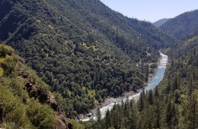
Stevens Trail stands as one of Northern California's most historically significant and visually stunning hiking destinations. Located just off Interstate 80 in Colfax, this trail provides hikers with an incredible journey through time, following the same route that Gold Rush miners used over 150 years ago. The trail descends through diverse ecosystems, from oak woodlands to riparian forests, ultimately reaching the crystal-clear waters of the North Fork American River.
Pro Tip from Experience
Start your hike early in the morning, especially during warmer months. I've learned that beginning before 7 AM not only helps you avoid the heat but also provides better parking opportunities and fewer crowds on the trail.
Historic Gold Rush Legacy
The Stevens Trail carries a remarkable story that dates back to the California Gold Rush era. Originally constructed in the 1870s under the direction of John Rutherford, an Iowa Hill miner and tanner, the trail was later completed by his partner, Truman Allen Stevens, whose name the trail bears today.
This historic route served as a vital toll road connecting the bustling mining town of Iowa Hill with the railroad town of Colfax. During the height of the Gold Rush (1870-1895), hundreds of miners would traverse this steep canyon path daily, carrying their hopes and supplies as they sought their fortunes in the Sierra Nevada foothills.
The trail was forgotten for decades until 1969, when Sacramento-area Boy Scout Eric Kiel rediscovered it as part of a scouting project. Today, Stevens Trail is listed on the National Register of Historic Places and is maintained by the Bureau of Land Management, preserving this important piece of California history for future generations.
Historical Highlights You'll Encounter
- • Original stone retaining walls built by Chinese railroad workers
- • Remnants of the Cape Horn Passage railroad cut
- • Historic mining cave approximately halfway down the trail
- • Old bridge foundations at the river crossing
- • Interpretive signs explaining the trail's Gold Rush significance
My Personal Experience on Stevens Trail
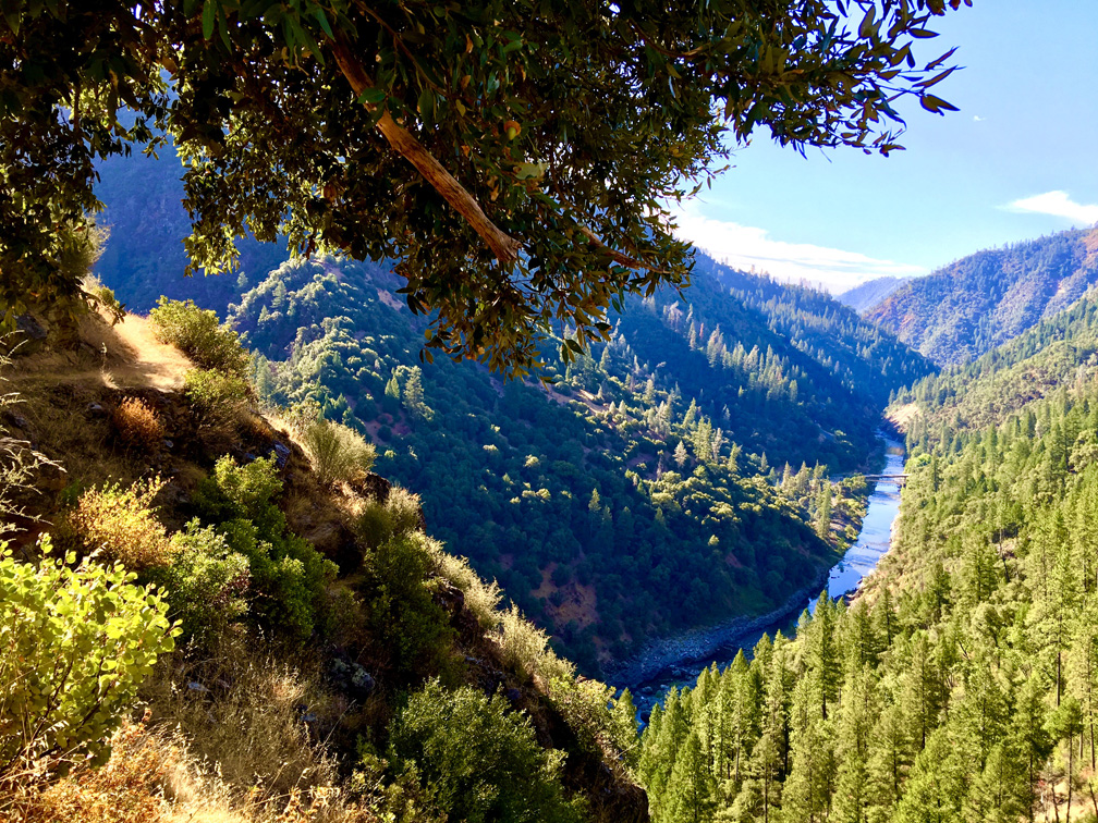
Having hiked Stevens Trail over a dozen times across different seasons, I can confidently say it's one of my favorite trails in Northern California. My first experience was during a crisp October morning when the fall colors were at their peak. The descent was invigorating, with each switchback revealing new vistas of the American River canyon.
What struck me most was the trail's incredible diversity. Within the first mile, you transition from chaparral and oak woodlands into cooler, more humid environments near seasonal creeks. The historic mining cave, located about 2 miles down, always fascinates visitors – though I always caution people to observe from a safe distance due to the potential presence of wildlife.
Lessons Learned from Multiple Visits
- • Spring (March-May): Wildflower displays are spectacular, waterfalls are flowing, but trails can be muddy
- • Fall (October-November): Perfect weather, beautiful colors, but can be crowded on weekends
- • Winter (December-February): Fewer crowds, cooler temperatures, occasional snow at higher elevations
- • Summer: Avoid midday hikes – I've witnessed heat exhaustion emergencies firsthand
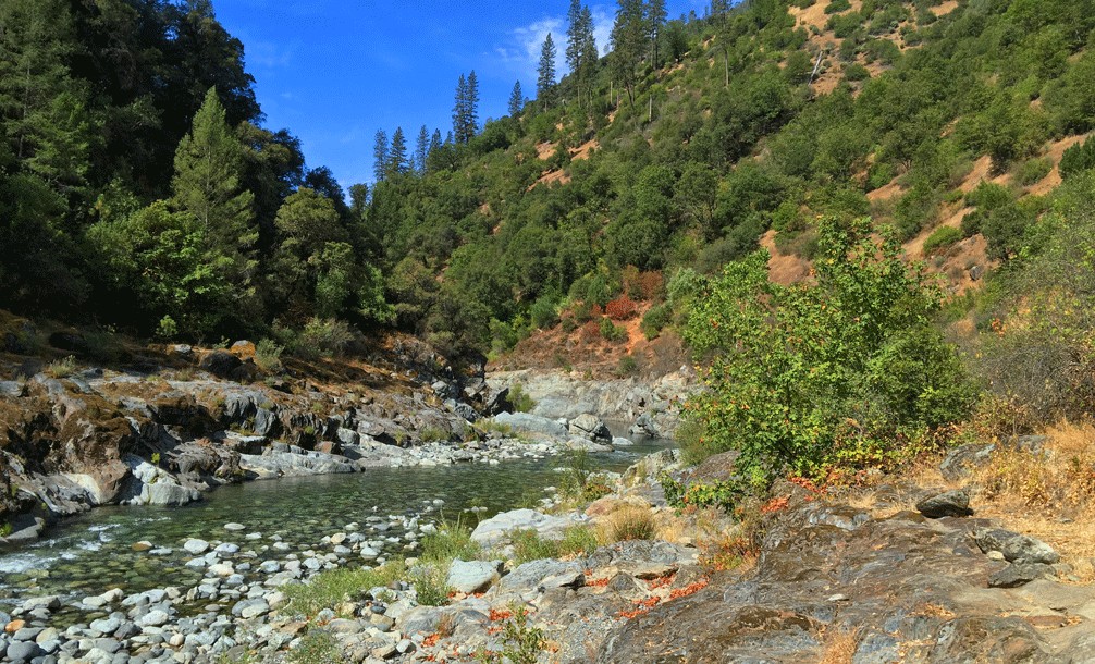
The reward at the end – reaching the North Fork American River – never gets old. The crystal-clear water, granite boulders, and swimming holes provide the perfect respite after the challenging descent. I've spent countless hours here, watching kayakers navigate the rapids and observing the diverse wildlife that calls this riparian environment home.
Important Safety Observation
During my summer visits, I've personally assisted park rangers with heat-related emergencies. The trail's exposure and steep return climb can be dangerous in temperatures above 85°F. Always carry more water than you think you'll need – I recommend at least 3 liters per person on warm days.
Detailed Trail Description
Getting to the Trailhead
From Auburn, take Interstate 80 east to the second Colfax exit. Turn left on the frontage road (N. Canyon Way) and continue for 0.6 miles. Look for the small parking area on your left with trail signage. The parking lot accommodates about 20-25 vehicles, so arriving early is crucial, especially on weekends.
Mile-by-Mile Trail Guide
Miles 0-1: The Descent Begins
The trail starts with a steep descent through oak and manzanita. You'll encounter the first of several switchbacks designed to make the grade manageable. Views of the canyon begin to open up after the first half-mile.
Miles 1-2: Historical Features
This section features the most significant historical remnants. You'll pass old stone retaining walls and reach the famous mining cave. The trail becomes more shaded as you enter Douglas fir and bay laurel groves.
Miles 2-3: Waterfall and Creek Crossings
During wet seasons, you'll encounter a beautiful cascading waterfall and several seasonal creek crossings. This is where the trail's famous shale formations become most prominent, creating a distinctive geological landscape.
Miles 3-3.8: River Approach
The final descent to the river involves navigating some rocky sections. The vegetation becomes more lush, and you'll start hearing the sound of flowing water. The trail ends at a large flat area perfect for rest and recreation.

Navigation Tips
The trail is well-marked, but download an offline map app like AllTrails before you go. Cell service can be spotty in the canyon. Key landmarks include the mining cave (mile 2), the waterfall (mile 2.5), and the large shale slide (mile 3).
Remember, what goes down must come up! The return journey requires more time and energy, with the steepest sections saved for last. Many hikers underestimate the challenge of the return climb, so pace yourself and take frequent breaks.
Essential Gear & Equipment
Having the right gear can make the difference between an enjoyable hike and a challenging ordeal. Based on my extensive experience on Stevens Trail and feedback from fellow hikers, here are my top recommendations for essential equipment.
Quality Hiking Boots
The rocky, steep terrain of Stevens Trail demands proper footwear. I personally use Danner Trail 2650s, which provide excellent ankle support and grip on loose rocks.
Check Price on AmazonReliable Day Pack
The Osprey Talon 22 is perfect for day hikes like Stevens Trail. It has excellent ventilation, multiple pockets, and a hydration reservoir sleeve for hands-free drinking.
Check Price on AmazonInsulated Water Bottle
Hydration is critical on Stevens Trail. The Hydro Flask 32oz keeps water cold for hours and has a wide mouth for easy refilling. I carry two of these on hot days.
Check Price on AmazonTrekking Poles
Black Diamond Trail poles are excellent for steep descents and the challenging return climb. They reduce knee stress and provide stability on loose rocks.
Check Price on AmazonCompact First Aid Kit
The Adventure Medical Kits Mountain Hiker is specifically designed for trail conditions. Essential for treating cuts, sprains, and dealing with emergencies until help arrives.
Check Price on AmazonComplete Packing Checklist
Essential Items:
- • 3+ liters of water per person
- • High-energy snacks and lunch
- • Sun hat and sunglasses
- • Sunscreen (SPF 30+)
- • Map and compass/GPS
- • Whistle for emergencies
Optional But Recommended:
- • Camera for scenic photos
- • Portable phone charger
- • Insect repellent (spring/summer)
- • Quick-dry towel for river
- • Cash for parking meter (if applicable)
- • Dog leash if bringing pets
For those interested in exploring more challenging adventures, consider checking out the Continental Divide Trail or the scenic Dipsea Trail for different hiking experiences. If you're looking for winter hiking options, the Northville-Placid Trail offers snow-covered beauty, while the Buckeye Trail provides a multi-state adventure.
Safety Tips & Precautions
Stevens Trail, while beautiful, presents several safety challenges that every hiker should be aware of. The combination of steep terrain, weather exposure, and remote location requires careful preparation and constant awareness.
Heat-Related Dangers
Summer temperatures regularly exceed 100°F in the canyon, with limited shade on the return climb. Heat exhaustion and heat stroke are serious risks that I've witnessed firsthand.
- • Never attempt this hike when temperatures exceed 85°F
- • Start before sunrise during warm months
- • Carry 1 gallon of water per person on hot days
- • Turn back immediately if you feel dizzy or nauseous
- • Wet your shirt and hat at the river before the return climb
Trail-Specific Hazards
- • Loose rocks and steep grades
- • Poison oak throughout the trail
- • Rattlesnakes (especially near mining cave)
- • Flash flood potential in creeks
- • Limited cell phone coverage
- • Unstable mining structures
Group Safety Protocol
- • Never hike alone - use the buddy system
- • Inform someone of your hiking plans
- • Carry a whistle for emergency signaling
- • Know basic first aid principles
- • Establish turnaround times
- • Stay together, especially on descent

Wildlife Safety Tips
During my many visits, I've encountered various wildlife including deer, wild turkeys, and occasionally black bears. Here's what you need to know:
- • Make noise when hiking to avoid surprising animals
- • Store food securely and never feed wildlife
- • Give rattlesnakes a wide berth - they're common in sunny, rocky areas
- • If you encounter a bear, don't run - make yourself appear large and back away slowly
- • Keep dogs on leash to prevent wildlife encounters
Emergency Contact Information
Emergency Services: 911 (limited coverage in canyon)
Placer County Sheriff: (530) 889-7800
BLM Mother Lode Field Office: (916) 941-3101
Poison Control: 1-800-222-1222
For additional safety information and gear recommendations, explore resources for challenging trails like the Chilkoot Trail or Chimney Tops Trail. If you're planning to visit other potentially hazardous trails, the Fiery Gizzard Trail offers similar challenges and rewards.
What Fellow Hikers Are Saying
"Well maintained trail. All downhill to the river…which means all up on the way back. But the inclines are not terribly pitchy. Beautiful views of the canyon after the first mile or so. Finished in 2:48."
- Recent Hiker
"Steven's Trail is nice, but there's a world to discover further up the river. Euchre Bar, Green Valley Trail, Mumford Bar... So much history, so beautiful and very desolate."
- Fairydust_supreme
"This is a great hike. Only 50 miles from Sacramento downtown. You can make it the full 9 miles or turn back at any point. Very nice to make it down to the river to cool off. Definitely bring extra water."
- TripAdvisor Reviewer
Pros and Cons Based on Community Feedback
What Hikers Love
- • Spectacular canyon and river views
- • Rich historical significance
- • Well-maintained trail with clear markers
- • Swimming opportunities at the river
- • Accessibility from major cities
- • Great workout for experienced hikers
Common Challenges
- • Extremely challenging return climb
- • Dangerous in hot weather
- • Limited parking on weekends
- • No shade on upper sections
- • Steep, loose rock sections
- • Can be crowded during peak times
Frequently Asked Questions
How difficult is Stevens Trail for beginner hikers?
Stevens Trail is rated as challenging and isn't recommended for true beginners. The 7.6-mile round trip with 1,620 feet of elevation gain requires good physical fitness and hiking experience. The steep descent is manageable, but the return climb is strenuous and can take 2-3 hours. Beginners should consider shorter, less challenging trails first to build their hiking endurance. If you do attempt it as a newer hiker, start very early, bring plenty of water, and consider the proper trail shoes to ensure safety.
What's the best time of year to hike Stevens Trail?
The optimal hiking season is October through May when temperatures are cooler and wildflowers bloom. Spring (March-May) offers spectacular wildflower displays and flowing waterfalls, but trails can be muddy. Fall (October-November) provides perfect weather and beautiful autumn colors. Winter hiking is possible but requires preparation for potential rain and mud. Avoid summer months (June-September) when canyon temperatures often exceed 100°F, making the hike dangerous. For winter hiking preparation, consider researching gear similar to what's needed for the Watchman Trail in colder conditions.
Is it safe to swim in the North Fork American River?
Swimming in the North Fork American River can be safe with proper precautions, but several factors require consideration. The water is typically cold year-round, even in summer, which can cause shock and hypothermia. Current strength varies with seasonal water levels – spring runoff creates dangerous rapids and swift currents. The safest swimming areas are the deeper pools with calmer water near the trail's end. Always enter slowly, never dive into unknown depths, and be aware of slippery rocks. Children should be closely supervised, and non-swimmers should avoid entering the water. Consider bringing proper trail boots with good grip for navigating wet, rocky areas safely.
Are dogs allowed on Stevens Trail?
Yes, dogs are allowed on Stevens Trail but must be kept on leash at all times. The trail presents several challenges for dogs including steep rocky sections, potential encounters with wildlife (especially rattlesnakes), and extreme heat exposure. Dog paws can be seriously burned on hot rocks during summer months. Bring plenty of water for your pet and consider protective booties for rocky sections. Be particularly cautious near the mining cave where snakes seek shelter. The steep return climb can be exhausting for dogs, especially in warm weather. Many hikers find that women's trail boots or specialized trail boots provide better grip for navigating these challenging sections with pets.
How long does it take to complete the Stevens Trail hike?
Most hikers complete Stevens Trail in 4-6 hours total. The descent typically takes 1.5-2 hours, while the challenging return climb requires 2.5-4 hours depending on fitness level, weather conditions, and rest breaks. Factor in additional time for lunch, photography, and potential swimming at the river. During hot weather, the return climb takes significantly longer due to necessary rest stops and slower pace. Early morning starts are crucial for completing the hike safely. Plan for the full day and inform someone of your expected return time. Consider the stamina requirements similar to other challenging trails like Grandfather Trail when planning your adventure.
What should I do if I encounter a rattlesnake on the trail?
Rattlesnake encounters are possible on Stevens Trail, especially near sunny, rocky areas and the historic mining cave. If you see or hear a rattlesnake, immediately stop and slowly back away while keeping the snake in sight. Never attempt to kill, capture, or get closer for photos. Give snakes at least 6 feet of clearance – they can strike up to 2/3 of their body length. Most snakes will retreat if given space and escape routes. Make noise while hiking to avoid surprising snakes. If someone is bitten, seek immediate medical attention and call 911. Keep the victim calm and still, remove jewelry before swelling occurs, and don't apply ice or tourniquets. For additional safety equipment recommendations, consider the gear used for trails with similar hazards like the Hillsound Trail system.
Conclusion
Stevens Trail represents one of Northern California's most rewarding hiking experiences, combining breathtaking natural beauty with fascinating Gold Rush history. This challenging 7.6-mile adventure takes you through diverse ecosystems, past historic mining sites, and down to the crystal-clear waters of the North Fork American River.
While the trail demands respect and proper preparation – especially regarding heat safety and physical fitness – the rewards are immense. From the spectacular canyon vistas to the refreshing river swimming holes, Stevens Trail offers an unforgettable connection with California's rich heritage and stunning Sierra Nevada landscapes.
Remember to start early, bring plenty of water, and respect both the historical significance and natural environment of this special place. Whether you're a local looking for a challenging day hike or a visitor exploring Northern California's outdoor treasures, Stevens Trail will leave you with lasting memories and a deep appreciation for the area's Gold Rush legacy.
Ready to explore more incredible trails? Discover additional adventures like the scenic Hoodoos Trail, the coastal Otter Trail, or the challenging Pohono Trail.
Explore More TrailsSafe travels and happy hiking! For more trail guides and outdoor gear recommendations, visit our Stevens Trail resource page.